
Carte topographique Stevenage
Cliquez sur la carte pour afficher l’altitude.
À propos de cette carte
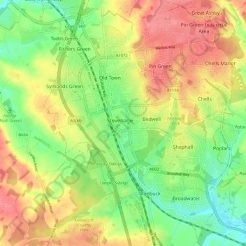
Nom : Carte topographique Stevenage, altitude, relief.
Lieu : Stevenage, Hertfordshire, England, United Kingdom (51.86932 -0.23438 51.93243 -0.14680)
Altitude moyenne : 108 m
Altitude minimum : 70 m
Altitude maximum : 147 m
Autres cartes topographiques
Cliquez sur une carte pour visualiser sa topographie, son altitude et son relief.
St Albans
United Kingdom > England > Hertfordshire > St Albans
St Albans was an ancient borough created following the dissolution of the monastery in 1539. It consisted of the ancient parish of St Albans (also known as the Abbey parish) and parts of St Michael and St Peter. The municipal corporation was reformed by the Municipal Corporations Act 1835 and the boundary was…
Altitude moyenne : 100 m
Letchworth
United Kingdom > England > Hertfordshire > North Hertfordshire > Letchworth
Altitude moyenne : 80 m
Knebworth Country Park
United Kingdom > England > Hertfordshire > North Hertfordshire > Knebworth
Altitude moyenne : 116 m
Spellbrook
United Kingdom > England > Hertfordshire > East Hertfordshire > Sawbridgeworth
Altitude moyenne : 71 m
Highfield Park
United Kingdom > England > Hertfordshire > St Albans > Colney Heath
Altitude moyenne : 87 m
Astonbury Wood
United Kingdom > England > Hertfordshire > East Hertfordshire > Aston
Altitude moyenne : 83 m
Ashbrook
United Kingdom > England > Hertfordshire > North Hertfordshire > St Ippolyts
Altitude moyenne : 85 m
Waterford
United Kingdom > England > Hertfordshire > East Hertfordshire > Waterford
Altitude moyenne : 66 m
Windmill Hill
United Kingdom > England > Hertfordshire > North Hertfordshire > Hitchin
Altitude moyenne : 74 m
Primrosehill
United Kingdom > England > Hertfordshire > Three Rivers > Abbots Langley
Altitude moyenne : 111 m
Saint Margarets Copse
United Kingdom > England > Hertfordshire > Dacorum > Great Gaddesden
Altitude moyenne : 144 m
Mardley Heath
United Kingdom > England > Hertfordshire > Welwyn Hatfield > Oaklands
Altitude moyenne : 110 m
Throcking
United Kingdom > England > Hertfordshire > East Hertfordshire > Buntingford
Altitude moyenne : 126 m
Hammerfield
United Kingdom > England > Hertfordshire > Dacorum > Hemel Hempstead
Altitude moyenne : 122 m
Temple Dinsley
United Kingdom > England > Hertfordshire > North Hertfordshire > Preston
Altitude moyenne : 124 m
Bendish
United Kingdom > England > Hertfordshire > North Hertfordshire > Breachwood Green
Altitude moyenne : 128 m
Gobions Pond
United Kingdom > England > Hertfordshire > Welwyn Hatfield > Brookmans Park > Swanley Bar
Altitude moyenne : 106 m
Blackmore End
United Kingdom > England > Hertfordshire > St Albans > Wheathampstead
Altitude moyenne : 114 m
Tewin Wood
United Kingdom > England > Hertfordshire > East Hertfordshire > Burnham Green
Altitude moyenne : 101 m
Tringford Reservoir
United Kingdom > England > Hertfordshire > Dacorum > Tring > Wilstone
Altitude moyenne : 119 m
Chapmore End
United Kingdom > England > Hertfordshire > East Hertfordshire > Tonwell
Altitude moyenne : 65 m
Stanstead St Margarets
United Kingdom > England > Hertfordshire > East Hertfordshire
Altitude moyenne : 48 m
Great Wymondley
United Kingdom > England > Hertfordshire > North Hertfordshire
Altitude moyenne : 87 m
Hadham Cross
United Kingdom > England > Hertfordshire > East Hertfordshire > Much Hadham
Altitude moyenne : 79 m
Thorley Street
United Kingdom > England > Hertfordshire > East Hertfordshire > Thorley
Altitude moyenne : 74 m
Peter's Green
United Kingdom > England > Hertfordshire > North Hertfordshire > Kimpton
Altitude moyenne : 133 m
Pimlico
United Kingdom > England > Hertfordshire > Three Rivers > Abbots Langley
Altitude moyenne : 123 m
The Rookery
United Kingdom > England > Hertfordshire > Three Rivers > Abbots Langley > Langleybury
Altitude moyenne : 92 m
Dixon's Gap Bridge
United Kingdom > England > Hertfordshire > Dacorum > Wilstone > Gubblecote
Altitude moyenne : 101 m
Whempstead
United Kingdom > England > Hertfordshire > East Hertfordshire > Dane End
Altitude moyenne : 95 m
Stanborough Park
United Kingdom > England > Hertfordshire > Welwyn Hatfield > Hatfield > Stanborough
Altitude moyenne : 79 m
Sarratt Bottom
United Kingdom > England > Hertfordshire > Three Rivers > Sarratt
Altitude moyenne : 112 m
Bushey
United Kingdom > England > Hertfordshire > Hertsmere
Bushey is a town in the Hertsmere borough of Hertfordshire in the East of England. It had a population of 25,328 in the 2011 census, rising to 28,416 in the 2021 census, an increase of 12.19%. This makes Bushey the second most populated town in Hertsmere. Bushey Heath is a large neighbourhood south east of…
Altitude moyenne : 88 m
Bentley Heath
United Kingdom > England > Hertfordshire > Hertsmere > Potters Bar
Altitude moyenne : 105 m
Church End
United Kingdom > England > Hertfordshire > East Hertfordshire > Little Hadham
Altitude moyenne : 95 m
Lower Gustard Wood
United Kingdom > England > Hertfordshire > St Albans > Wheathampstead
Altitude moyenne : 112 m
Westbrook Mere
United Kingdom > England > Hertfordshire > Dacorum > Bourne End
Altitude moyenne : 125 m
Trowley Bottom
United Kingdom > England > Hertfordshire > Dacorum > Flamstead
Altitude moyenne : 139 m
Crab's Green
United Kingdom > England > Hertfordshire > East Hertfordshire > Stocking Pelham
Altitude moyenne : 111 m