
Faire un don
Équipez-vous pour votre prochaine aventure :
En tant que Partenaire Amazon, ce site perçoit une commission sur les achats éligibles sans surcoût pour vous.
Carte topographique Kirkland Lake
Cliquez sur la carte pour afficher l’altitude.
Faire un don
Équipez-vous pour votre prochaine aventure :
En tant que Partenaire Amazon, ce site perçoit une commission sur les achats éligibles sans surcoût pour vous.
Kirkland Lake
Kirkland Lake is located in the resource-rich Precambrian Shield, an ancient geological core of the North American continent. Nearby is the Arctic Watershed, a drainage divide at an elevation of 318 m (1,043 ft). Rivers south of that elevation flow into a drainage basin which includes Lake Ontario and the Saint Lawrence River, while rivers north of the watershed flow into Hudson Bay.
Faire un don
Équipez-vous pour votre prochaine aventure :
En tant que Partenaire Amazon, ce site perçoit une commission sur les achats éligibles sans surcoût pour vous.
À propos de cette carte
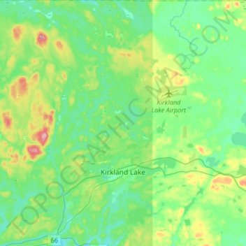
Nom : Carte topographique Kirkland Lake, altitude, relief.
Altitude moyenne : 332 m
Altitude minimum : 294 m
Altitude maximum : 443 m
Faire un don
Équipez-vous pour votre prochaine aventure :
En tant que Partenaire Amazon, ce site perçoit une commission sur les achats éligibles sans surcoût pour vous.
Autres cartes topographiques
Cliquez sur une carte pour visualiser sa topographie, son altitude et son relief.
Henwood Lake
Canada > Ontario > Timiskaming District > Unorganized West Timiskaming
Altitude moyenne : 288 m
Faire un don
Équipez-vous pour votre prochaine aventure :
En tant que Partenaire Amazon, ce site perçoit une commission sur les achats éligibles sans surcoût pour vous.
Faire un don
Équipez-vous pour votre prochaine aventure :
En tant que Partenaire Amazon, ce site perçoit une commission sur les achats éligibles sans surcoût pour vous.
Boston Creek
Canada > Ontario > Timiskaming District > Unorganized West Timiskaming
Altitude moyenne : 300 m
Heart Lake
Canada > Ontario > Timiskaming District > Unorganized West Timiskaming > King Kirkland
Altitude moyenne : 336 m
Faire un don
Équipez-vous pour votre prochaine aventure :
En tant que Partenaire Amazon, ce site perçoit une commission sur les achats éligibles sans surcoût pour vous.
Kenabeek
Canada > Ontario > Timiskaming District > Unorganized West Timiskaming
Altitude moyenne : 284 m
Hobart Lake
Canada > Ontario > Timiskaming District > Unorganized West Timiskaming
Altitude moyenne : 305 m
Flanagan Lake
Canada > Ontario > Timiskaming District > Unorganized West Timiskaming
Altitude moyenne : 403 m
Faire un don
Équipez-vous pour votre prochaine aventure :
En tant que Partenaire Amazon, ce site perçoit une commission sur les achats éligibles sans surcoût pour vous.
Baptiste Creek;Baptiste Lake
Canada > Ontario > Timiskaming District > Unorganized West Timiskaming
Altitude moyenne : 334 m
Faire un don
Équipez-vous pour votre prochaine aventure :
En tant que Partenaire Amazon, ce site perçoit une commission sur les achats éligibles sans surcoût pour vous.