
Faire un don
Équipez-vous pour votre prochaine aventure :
En tant que Partenaire Amazon, ce site perçoit une commission sur les achats éligibles sans surcoût pour vous.
Carte topographique Sungai Rompin
Cliquez sur la carte pour afficher l’altitude.
Faire un don
Équipez-vous pour votre prochaine aventure :
En tant que Partenaire Amazon, ce site perçoit une commission sur les achats éligibles sans surcoût pour vous.
À propos de cette carte
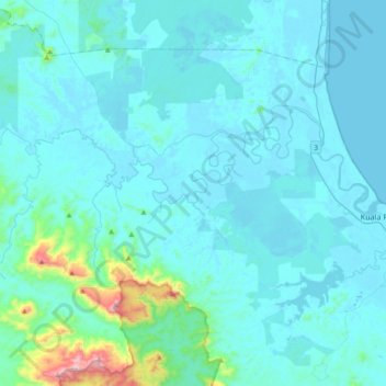
Nom : Carte topographique Sungai Rompin, altitude, relief.
Lieu : Sungai Rompin, Pahang, Malaysia (2.74691 103.11298 2.90971 103.48211)
Altitude moyenne : 66 m
Altitude minimum : -3 m
Altitude maximum : 821 m
Faire un don
Équipez-vous pour votre prochaine aventure :
En tant que Partenaire Amazon, ce site perçoit une commission sur les achats éligibles sans surcoût pour vous.
Autres cartes topographiques
Cliquez sur une carte pour visualiser sa topographie, son altitude et son relief.
Kampung Janda Baik
Before Janda Baik was founded in 1930, the area was primarily inhabited by Orang Asli tribes. The village was founded when some residents moved from Bentong to an area with a higher elevation due to the 1926 floods that affected Bentong and other low elevation areas. The earliest founders for this village are…
Altitude moyenne : 467 m
Cameron Highlands
Surveyed by the government geologist and explorer William Cameron in 1885, the outpost consists of three mukims (subdistricts), namely Ringlet, Tanah Rata and Ulu Telom. Its eight settlements are Ringlet, Tanah Rata (the administrative centre), Brinchang, the Bertam Valley, Kea Farm, Tringkap, Kampung Kuala…
Altitude moyenne : 1 400 m
Genting Highlands
Genting Highlands is a hill station located on the peak of Mount Ulu Kali in the Titiwangsa Mountains, central Peninsular Malaysia, at 1800 metres elevation. Located in the state of Pahang, it was established in 1965 by the late Malaysian businessman Lim Goh Tong. The primary tourist attraction is Resorts…
Altitude moyenne : 1 141 m
Faire un don
Équipez-vous pour votre prochaine aventure :
En tant que Partenaire Amazon, ce site perçoit une commission sur les achats éligibles sans surcoût pour vous.
Pahang
The highest peak, Mount Tahan, reaches 2,187 m (7,175 ft) in elevation, which is also the highest point in the Peninsular Malaysia. The climate is temperate enough to have distinct temperature variations year round, and much of the highlands are covered with tropical rainforest. Pahang is home to Malaysia's…
Altitude moyenne : 90 m
Faire un don
Équipez-vous pour votre prochaine aventure :
En tant que Partenaire Amazon, ce site perçoit une commission sur les achats éligibles sans surcoût pour vous.
Faire un don
Équipez-vous pour votre prochaine aventure :
En tant que Partenaire Amazon, ce site perçoit une commission sur les achats éligibles sans surcoût pour vous.
Tioman Island
Local mythology claims that the island is the embodiment of the mighty dragon Sri Gumom. The dragon was on his way to visit his sister Gunung Linga (Lingin Peak). Still, the great Sri Rama forbade the meeting, and Sri Gumom was turned into a stone and fell into the deep sea where he now remains, frozen in…
Altitude moyenne : 104 m
Faire un don
Équipez-vous pour votre prochaine aventure :
En tant que Partenaire Amazon, ce site perçoit une commission sur les achats éligibles sans surcoût pour vous.
Brinchang
Brinchang (also spelt Berincang) is a town and hill resort located at an altitude of 1,540 metres (5,050 ft) in Cameron Highlands in the state of Pahang, Malaysia. The town's name is derived from nearby Gunung Brinchang, which is the second highest point in Cameron Highlands.
Altitude moyenne : 1 524 m
Faire un don
Équipez-vous pour votre prochaine aventure :
En tant que Partenaire Amazon, ce site perçoit une commission sur les achats éligibles sans surcoût pour vous.
Padang SMK Jengka Pusat
Malaysia > Pahang > Bandar Tun Abdul Razak (Bandar Jengka)
Altitude moyenne : 75 m
Brinchang
Brinchang (also spelt Berincang) is a town and hill resort located at an altitude of 1,540 metres (5,050 ft) in Cameron Highlands in the state of Pahang, Malaysia. The town's name is derived from nearby Gunung Brinchang, which is the second highest point in Cameron Highlands.
Altitude moyenne : 1 524 m
Faire un don
Équipez-vous pour votre prochaine aventure :
En tant que Partenaire Amazon, ce site perçoit une commission sur les achats éligibles sans surcoût pour vous.
Genting Highlands
Genting Highlands is a hill station located on the peak of Mount Ulu Kali in the Titiwangsa Mountains, central Peninsular Malaysia, at 1800 metres elevation. Located in the state of Pahang, it was established in 1965 by the late Malaysian businessman Lim Goh Tong. The primary tourist attraction is Resorts…
Altitude moyenne : 1 141 m
Genting Highlands
Genting Highlands is a hill station and a city located on the peak of Mount Ulu Kali in the Titiwangsa Mountains, central Peninsular Malaysia, at 1800 metres elevation. It is the second seat of Bentong District after Bentong. Located in the state of Pahang. It was established in 1965 by the late Malaysian…
Altitude moyenne : 1 141 m
Faire un don
Équipez-vous pour votre prochaine aventure :
En tant que Partenaire Amazon, ce site perçoit une commission sur les achats éligibles sans surcoût pour vous.
Faire un don
Équipez-vous pour votre prochaine aventure :
En tant que Partenaire Amazon, ce site perçoit une commission sur les achats éligibles sans surcoût pour vous.
Tanah Rata
Tanah Rata is a town located in Cameron Highlands, Pahang, Malaysia. The name "tanah rata" means flat ground in Malay and it refers to the relatively flat area on which the town is located amidst this highland region. It has an elevation of 1,440 metres (4,720 ft).
Altitude moyenne : 1 393 m
Faire un don
Équipez-vous pour votre prochaine aventure :
En tant que Partenaire Amazon, ce site perçoit une commission sur les achats éligibles sans surcoût pour vous.
Malay Peninsula
The Kangar-Pattani floristic boundary crosses the peninsula in southern Thailand and northernmost Malaysia, marking the boundary between the large biogeographic regions of Indochina to the north and Sundaland and Malesia to the south. The forests north of the boundary are characterized by seasonally-deciduous…
Altitude moyenne : 140 m
Faire un don
Équipez-vous pour votre prochaine aventure :
En tant que Partenaire Amazon, ce site perçoit une commission sur les achats éligibles sans surcoût pour vous.
Faire un don
Équipez-vous pour votre prochaine aventure :
En tant que Partenaire Amazon, ce site perçoit une commission sur les achats éligibles sans surcoût pour vous.
Faire un don
Équipez-vous pour votre prochaine aventure :
En tant que Partenaire Amazon, ce site perçoit une commission sur les achats éligibles sans surcoût pour vous.
Malay Peninsula
Malaysia > Pahang > Damak > Benta
The Kangar-Pattani floristic boundary crosses the peninsula in southern Thailand and northernmost Malaysia, marking the boundary between the large biogeographic regions of Indochina to the north and Sundaland and Malesia to the south. The forests north of the boundary are characterized by seasonally-deciduous…
Altitude moyenne : 131 m
Faire un don
Équipez-vous pour votre prochaine aventure :
En tant que Partenaire Amazon, ce site perçoit une commission sur les achats éligibles sans surcoût pour vous.
Malay Peninsula
The Kangar-Pattani floristic boundary crosses the peninsula in southern Thailand and northernmost Malaysia, marking the boundary between the large biogeographic regions of Indochina to the north and Sundaland and Malesia to the south. The forests north of the boundary are characterized by seasonally-deciduous…
Altitude moyenne : 140 m
Cameron Highlands
Surveyed by the government geologist and explorer William Cameron in 1885, the outpost consists of three mukims (subdistricts), namely Ringlet, Tanah Rata and Ulu Telom. Its eight settlements are Ringlet, Tanah Rata (the administrative centre), Brinchang, the Bertam Valley, Kea Farm, Tringkap, Kampung Kuala…
Altitude moyenne : 1 400 m
Faire un don
Équipez-vous pour votre prochaine aventure :
En tant que Partenaire Amazon, ce site perçoit une commission sur les achats éligibles sans surcoût pour vous.
Mount Tahan
Mount Tahan (Malay: Gunung Tahan), is the highest point in Peninsular Malaysia with an elevation of 7,175 ft (2,187 m) above sea level. It is located within the Taman Negara national forest, in the state of Pahang. The mountain is part of the Tahan Range in the Tenasserim Hills and is popular with local…
Altitude moyenne : 1 829 m
Faire un don
Équipez-vous pour votre prochaine aventure :
En tant que Partenaire Amazon, ce site perçoit une commission sur les achats éligibles sans surcoût pour vous.
Fraser's Hill
Initially, Fraser was reported as having disappeared in 1910, however, the latest research by R. Hale in 2019 uncovered that he retired from his position and returned to Great Britain in 1910 and died while vacationing in Austria-Hungary in 1916. When C. J. Ferguson-Davie, the bishop of Singapore, attempted to…
Altitude moyenne : 1 093 m
Mount Tahan
Mount Tahan (Malay: Gunung Tahan), is the highest point in Peninsular Malaysia with an elevation of 2,187 m (7,175 ft) above sea level, on the border between the states of Pahang and Kelantan, with the peak lying on the Pahangite side. It is part of the Taman Negara that straddles Jerantut District in Pahang,…
Altitude moyenne : 1 829 m
Faire un don
Équipez-vous pour votre prochaine aventure :
En tant que Partenaire Amazon, ce site perçoit une commission sur les achats éligibles sans surcoût pour vous.
Faire un don
Équipez-vous pour votre prochaine aventure :
En tant que Partenaire Amazon, ce site perçoit une commission sur les achats éligibles sans surcoût pour vous.
Faire un don
Équipez-vous pour votre prochaine aventure :
En tant que Partenaire Amazon, ce site perçoit une commission sur les achats éligibles sans surcoût pour vous.
Tanah Rata
Tanah Rata is a town located in Cameron Highlands, Pahang, Malaysia. The name "tanah rata" means flat ground in Malay and it refers to the relatively flat area on which the town is located amidst this highland region. It has an elevation of 1,440 metres (4,720 ft).
Altitude moyenne : 1 393 m
Faire un don
Équipez-vous pour votre prochaine aventure :
En tant que Partenaire Amazon, ce site perçoit une commission sur les achats éligibles sans surcoût pour vous.
Faire un don
Équipez-vous pour votre prochaine aventure :
En tant que Partenaire Amazon, ce site perçoit une commission sur les achats éligibles sans surcoût pour vous.
Faire un don
Équipez-vous pour votre prochaine aventure :
En tant que Partenaire Amazon, ce site perçoit une commission sur les achats éligibles sans surcoût pour vous.
Faire un don
Équipez-vous pour votre prochaine aventure :
En tant que Partenaire Amazon, ce site perçoit une commission sur les achats éligibles sans surcoût pour vous.
Faire un don
Équipez-vous pour votre prochaine aventure :
En tant que Partenaire Amazon, ce site perçoit une commission sur les achats éligibles sans surcoût pour vous.
Faire un don
Équipez-vous pour votre prochaine aventure :
En tant que Partenaire Amazon, ce site perçoit une commission sur les achats éligibles sans surcoût pour vous.