
Faire un don
Équipez-vous pour votre prochaine aventure :
En tant que Partenaire Amazon, ce site perçoit une commission sur les achats éligibles sans surcoût pour vous.
Carte topographique Fraser's Hill
Cliquez sur la carte pour afficher l’altitude.
Faire un don
Équipez-vous pour votre prochaine aventure :
En tant que Partenaire Amazon, ce site perçoit une commission sur les achats éligibles sans surcoût pour vous.
Fraser's Hill
Initially, Fraser was reported as having disappeared in 1910, however, the latest research by R. Hale in 2019 uncovered that he retired from his position and returned to Great Britain in 1910 and died while vacationing in Austria-Hungary in 1916. When C. J. Ferguson-Davie, the bishop of Singapore, attempted to find Fraser in 1917, he was unable to find him. Instead, he discovered the place was suitable for building a hill station as a retreat from the valley's hot climate. He wrote a report to the high commissioner and chief secretary of the Federated Malay States to suggest that a hill station be built at this location. A preliminary topographical survey was drawn up in August 1919, which confirmed the area was a suitable location for a hill station. Later, R.C.M. Kindersly, an unofficial member of the Federal Council, told the committee that it aimed to make the Fraser's Hill area a holiday resort. Construction of Fraser's Hill began in October 1919 when F.W. Mager, Pahang state engineer, surveyed the site for building construction and cleared the land around Fraser's former bungalow to build a road from The Gap to provide access to the hill station. The place was renamed Fraser's Hill and opened to visitors in 1922.
Faire un don
Équipez-vous pour votre prochaine aventure :
En tant que Partenaire Amazon, ce site perçoit une commission sur les achats éligibles sans surcoût pour vous.
À propos de cette carte
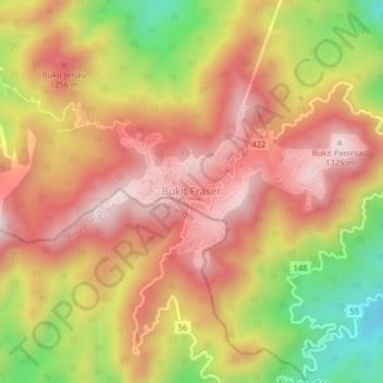
Nom : Carte topographique Fraser's Hill, altitude, relief.
Lieu : Fraser's Hill, Raub, Pahang, Malaysia (3.69305 101.71656 3.73305 101.75656)
Altitude moyenne : 1 093 m
Altitude minimum : 760 m
Altitude maximum : 1 320 m
Faire un don
Équipez-vous pour votre prochaine aventure :
En tant que Partenaire Amazon, ce site perçoit une commission sur les achats éligibles sans surcoût pour vous.
Autres cartes topographiques
Cliquez sur une carte pour visualiser sa topographie, son altitude et son relief.
Cameron Highlands
Surveyed by the government geologist and explorer William Cameron in 1885, the outpost consists of three mukims (subdistricts), namely Ringlet, Tanah Rata and Ulu Telom. Its eight settlements are Ringlet, Tanah Rata (the administrative centre), Brinchang, the Bertam Valley, Kea Farm, Tringkap, Kampung Kuala…
Altitude moyenne : 1 117 m
Faire un don
Équipez-vous pour votre prochaine aventure :
En tant que Partenaire Amazon, ce site perçoit une commission sur les achats éligibles sans surcoût pour vous.
Tioman Island
Local mythology claims that the island is the embodiment of the mighty dragon Sri Gumom. The dragon was on his way to visit his sister Gunung Linga (Lingin Peak). Still, the great Sri Rama forbade the meeting, and Sri Gumom was turned into a stone and fell into the deep sea where he now remains, frozen in…
Altitude moyenne : 104 m
Faire un don
Équipez-vous pour votre prochaine aventure :
En tant que Partenaire Amazon, ce site perçoit une commission sur les achats éligibles sans surcoût pour vous.
Padang SMK Jengka Pusat
Malaysia > Pahang > Bandar Tun Abdul Razak (Bandar Jengka)
Altitude moyenne : 75 m
Malaysia National Park
Taman Negara has a total area of 4,343 km2 and it is one of the world's oldest rainforests, estimated to be more than 130 million years old. Mount Tahan, Peninsular Malaysia's highest point with an elevation of 7,175 ft (2,187 m) above sea level, is within the park's boundaries. Taman Negara is an important…
Altitude moyenne : 316 m
Faire un don
Équipez-vous pour votre prochaine aventure :
En tant que Partenaire Amazon, ce site perçoit une commission sur les achats éligibles sans surcoût pour vous.
Faire un don
Équipez-vous pour votre prochaine aventure :
En tant que Partenaire Amazon, ce site perçoit une commission sur les achats éligibles sans surcoût pour vous.
Faire un don
Équipez-vous pour votre prochaine aventure :
En tant que Partenaire Amazon, ce site perçoit une commission sur les achats éligibles sans surcoût pour vous.
Faire un don
Équipez-vous pour votre prochaine aventure :
En tant que Partenaire Amazon, ce site perçoit une commission sur les achats éligibles sans surcoût pour vous.
Faire un don
Équipez-vous pour votre prochaine aventure :
En tant que Partenaire Amazon, ce site perçoit une commission sur les achats éligibles sans surcoût pour vous.
Cameron Highlands
Surveyed by the government geologist and explorer William Cameron in 1885, the outpost consists of three mukims (subdistricts), namely Ringlet, Tanah Rata and Ulu Telom. Its eight settlements are Ringlet, Tanah Rata (the administrative centre), Brinchang, the Bertam Valley, Kea Farm, Tringkap, Kampung Kuala…
Altitude moyenne : 1 117 m
Faire un don
Équipez-vous pour votre prochaine aventure :
En tant que Partenaire Amazon, ce site perçoit une commission sur les achats éligibles sans surcoût pour vous.
Tioman Island
Local mythology claims that the island is the embodiment of the mighty dragon Sri Gumom. The dragon was on his way to visit his sister Gunung Linga (Lingin Peak). Still, the great Sri Rama forbade the meeting, and Sri Gumom was turned into a stone and fell into the deep sea where he now remains, frozen in…
Altitude moyenne : 104 m
Faire un don
Équipez-vous pour votre prochaine aventure :
En tant que Partenaire Amazon, ce site perçoit une commission sur les achats éligibles sans surcoût pour vous.
Faire un don
Équipez-vous pour votre prochaine aventure :
En tant que Partenaire Amazon, ce site perçoit une commission sur les achats éligibles sans surcoût pour vous.
Faire un don
Équipez-vous pour votre prochaine aventure :
En tant que Partenaire Amazon, ce site perçoit une commission sur les achats éligibles sans surcoût pour vous.
Faire un don
Équipez-vous pour votre prochaine aventure :
En tant que Partenaire Amazon, ce site perçoit une commission sur les achats éligibles sans surcoût pour vous.
Faire un don
Équipez-vous pour votre prochaine aventure :
En tant que Partenaire Amazon, ce site perçoit une commission sur les achats éligibles sans surcoût pour vous.
Sungai Ruan
Covering a total area of 9.7 square km at an average elevation of 227 meters above sea level, the village is surrounded by hills, forest and plantations with a population of about 6,000 people.
Altitude moyenne : 142 m
Padang SMK Jengka Pusat
Malaysia > Pahang > Bandar Tun Abdul Razak (Bandar Jengka)
Altitude moyenne : 75 m
Faire un don
Équipez-vous pour votre prochaine aventure :
En tant que Partenaire Amazon, ce site perçoit une commission sur les achats éligibles sans surcoût pour vous.
Taman Awam Kubang Gajah
Malaysia > Pahang > Temerloh > Kampung Pengkalan Manggis
Altitude moyenne : 39 m
Cameron Highlands
Surveyed by the government geologist and explorer William Cameron in 1885, the outpost consists of three mukims (subdistricts), namely Ringlet, Tanah Rata and Ulu Telom. Its eight settlements are Ringlet, Tanah Rata (the administrative centre), Brinchang, the Bertam Valley, Kea Farm, Tringkap, Kampung Kuala…
Altitude moyenne : 1 105 m
Faire un don
Équipez-vous pour votre prochaine aventure :
En tant que Partenaire Amazon, ce site perçoit une commission sur les achats éligibles sans surcoût pour vous.
Faire un don
Équipez-vous pour votre prochaine aventure :
En tant que Partenaire Amazon, ce site perçoit une commission sur les achats éligibles sans surcoût pour vous.
Faire un don
Équipez-vous pour votre prochaine aventure :
En tant que Partenaire Amazon, ce site perçoit une commission sur les achats éligibles sans surcoût pour vous.
Faire un don
Équipez-vous pour votre prochaine aventure :
En tant que Partenaire Amazon, ce site perçoit une commission sur les achats éligibles sans surcoût pour vous.
Faire un don
Équipez-vous pour votre prochaine aventure :
En tant que Partenaire Amazon, ce site perçoit une commission sur les achats éligibles sans surcoût pour vous.
Faire un don
Équipez-vous pour votre prochaine aventure :
En tant que Partenaire Amazon, ce site perçoit une commission sur les achats éligibles sans surcoût pour vous.
Faire un don
Équipez-vous pour votre prochaine aventure :
En tant que Partenaire Amazon, ce site perçoit une commission sur les achats éligibles sans surcoût pour vous.
Faire un don
Équipez-vous pour votre prochaine aventure :
En tant que Partenaire Amazon, ce site perçoit une commission sur les achats éligibles sans surcoût pour vous.
Cameron Highlands
Surveyed by the government geologist and explorer William Cameron in 1885, the outpost consists of three mukims (subdistricts), namely Ringlet, Tanah Rata and Ulu Telom. Its eight settlements are Ringlet, Tanah Rata (the administrative centre), Brinchang, the Bertam Valley, Kea Farm, Tringkap, Kampung Kuala…
Altitude moyenne : 1 117 m
Faire un don
Équipez-vous pour votre prochaine aventure :
En tant que Partenaire Amazon, ce site perçoit une commission sur les achats éligibles sans surcoût pour vous.
Faire un don
Équipez-vous pour votre prochaine aventure :
En tant que Partenaire Amazon, ce site perçoit une commission sur les achats éligibles sans surcoût pour vous.
Faire un don
Équipez-vous pour votre prochaine aventure :
En tant que Partenaire Amazon, ce site perçoit une commission sur les achats éligibles sans surcoût pour vous.