
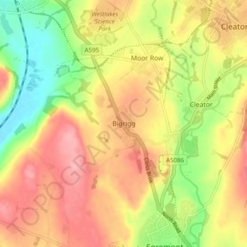
Carte topographique Bigrigg
Carte interactive
Cliquez sur la carte pour afficher l’altitude.
À propos de cette carte
Nom : Carte topographique Bigrigg, altitude, relief.
Altitude moyenne : 75 m
Altitude minimum : 8 m
Altitude maximum : 132 m
Autres cartes topographiques
Cliquez sur une carte pour visualiser sa topographie, son altitude et son relief.
Redhills Quarry (disused, flooded)
United Kingdom > England > Cumbria > Borough of Copeland > Millom > Rottington
Redhills Quarry (disused, flooded), Rottington, Millom, Borough of Copeland, Cumbria, England, United Kingdom
Altitude moyenne : 6 m
Sca Fell
United Kingdom > England > Cumbria > Borough of Copeland
Sca Fell, Borough of Copeland, Cumbria, England, CA20 1EX, United Kingdom
Altitude moyenne : 619 m
Mosedale
United Kingdom > England > Cumbria > Borough of Copeland
Mosedale, Wasdale, Borough of Copeland, Cumbria, England, CA20 1EX, United Kingdom
Altitude moyenne : 405 m
Distington
United Kingdom > England > Cumbria > Borough of Copeland
Distington, Borough of Copeland, Cumbria, England, United Kingdom
Altitude moyenne : 130 m
Ravenglass
United Kingdom > England > Cumbria > Borough of Copeland
Ravenglass, Borough of Copeland, Cumbria, England, CA18 1SE, United Kingdom
Altitude moyenne : 21 m
Blea Tarn
United Kingdom > England > Cumbria > Borough of Copeland > Boot > Beckfoot
Blea Tarn, Beckfoot, Eskdale, Boot, Borough of Copeland, Cumbria, England, United Kingdom
Altitude moyenne : 144 m