
Faire un don
Équipez-vous pour votre prochaine aventure :
En tant que Partenaire Amazon, ce site perçoit une commission sur les achats éligibles sans surcoût pour vous.
Carte topographique Central Park
Cliquez sur la carte pour afficher l’altitude.
Faire un don
Équipez-vous pour votre prochaine aventure :
En tant que Partenaire Amazon, ce site perçoit une commission sur les achats éligibles sans surcoût pour vous.
À propos de cette carte
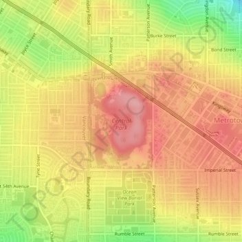
Nom : Carte topographique Central Park, altitude, relief.
Altitude moyenne : 113 m
Altitude minimum : 40 m
Altitude maximum : 156 m
Faire un don
Équipez-vous pour votre prochaine aventure :
En tant que Partenaire Amazon, ce site perçoit une commission sur les achats éligibles sans surcoût pour vous.
Autres cartes topographiques
Cliquez sur une carte pour visualiser sa topographie, son altitude et son relief.
Burnaby
Canada > British Columbia > Metro Vancouver Regional District > Burnaby
Burnaby occupies 98.60 square kilometres (38.07 sq mi) and is located at the geographic centre of the Metro Vancouver area and home to the Metro Vancouver regional government in Metrotown. Situated between the city of Vancouver on the west and Port Moody, Coquitlam, and New Westminster on the east, Burnaby is…
Altitude moyenne : 144 m
Burnaby Mountain
Canada > British Columbia > Metro Vancouver Regional District > Burnaby
Due to its relatively high elevation, snow will often fall on the higher levels of Burnaby Mountain while rain falls in the surrounding cities. Tobogganing is a popular pastime at Centennial Park on winter days with snow.
Altitude moyenne : 167 m
Deer Lake Park
Canada > British Columbia > Metro Vancouver Regional District > Burnaby
Altitude moyenne : 64 m
Burnaby Lake
Canada > British Columbia > Metro Vancouver Regional District > Burnaby
Altitude moyenne : 32 m
Faire un don
Équipez-vous pour votre prochaine aventure :
En tant que Partenaire Amazon, ce site perçoit une commission sur les achats éligibles sans surcoût pour vous.
Brentwood
Canada > British Columbia > Metro Vancouver Regional District > Burnaby
Altitude moyenne : 69 m
Stride Hill
Canada > British Columbia > Metro Vancouver Regional District > Burnaby
Altitude moyenne : 68 m
Maywood
Canada > British Columbia > Metro Vancouver Regional District > Burnaby
Altitude moyenne : 113 m
Deer Lake
Canada > British Columbia > Metro Vancouver Regional District > Burnaby
Altitude moyenne : 60 m
Faire un don
Équipez-vous pour votre prochaine aventure :
En tant que Partenaire Amazon, ce site perçoit une commission sur les achats éligibles sans surcoût pour vous.
Government Road
Canada > British Columbia > Metro Vancouver Regional District > Burnaby
Altitude moyenne : 45 m
Burnaby Mountain
Canada > British Columbia > Metro Vancouver Regional District > Burnaby
Due to its relatively high elevation, snow will often fall on the higher levels of Burnaby Mountain while rain falls in the surrounding cities. Tobogganing is a popular pastime at Centennial Park on winter days with snow.
Altitude moyenne : 167 m