
Carte topographique Oschersleben
Carte interactive
Cliquez sur la carte pour afficher l’altitude.
À propos de cette carte
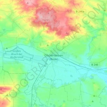
Nom : Carte topographique Oschersleben, altitude, relief.
Lieu : Oschersleben, Börde, Saksen-Anhalt, 39387, Duitsland (51.95572 11.12857 52.10909 11.40960)
Altitude moyenne : 112 m
Altitude minimum : 72 m
Altitude maximum : 218 m
Autres cartes topographiques
Cliquez sur une carte pour visualiser sa topographie, son altitude et son relief.
Flechtingen
Duitsland > Saksen-Anhalt > Börde
Flechtingen, Börde, Saksen-Anhalt, Duitsland
Altitude moyenne : 105 m
Dorst
Duitsland > Saksen-Anhalt > Börde > Calvörde
Dorst, Calvörde, Flechtingen, Börde, Saksen-Anhalt, Duitsland
Altitude moyenne : 65 m
Beendorf
Duitsland > Saksen-Anhalt > Börde
Beendorf, Flechtingen, Börde, Saksen-Anhalt, Duitsland
Altitude moyenne : 134 m