
Carte topographique Flechtingen
Carte interactive
Cliquez sur la carte pour afficher l’altitude.
À propos de cette carte
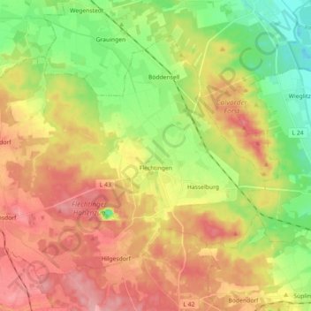
Nom : Carte topographique Flechtingen, altitude, relief.
Lieu : Flechtingen, Börde, Saksen-Anhalt, Duitsland (52.29421 11.12397 52.37855 11.30242)
Altitude moyenne : 105 m
Altitude minimum : 49 m
Altitude maximum : 162 m
Autres cartes topographiques
Cliquez sur une carte pour visualiser sa topographie, son altitude et son relief.
Dorst
Duitsland > Saksen-Anhalt > Börde > Calvörde
Dorst, Calvörde, Flechtingen, Börde, Saksen-Anhalt, Duitsland
Altitude moyenne : 65 m
Oschersleben
Duitsland > Saksen-Anhalt > Börde
Oschersleben, Börde, Saksen-Anhalt, 39387, Duitsland
Altitude moyenne : 112 m
Beendorf
Duitsland > Saksen-Anhalt > Börde
Beendorf, Flechtingen, Börde, Saksen-Anhalt, Duitsland
Altitude moyenne : 134 m