
Faire un don
Équipez-vous pour votre prochaine aventure :
En tant que Partenaire Amazon, ce site perçoit une commission sur les achats éligibles sans surcoût pour vous.
Carte topographique Blood Mountain
Cliquez sur la carte pour afficher l’altitude.
Faire un don
Équipez-vous pour votre prochaine aventure :
En tant que Partenaire Amazon, ce site perçoit une commission sur les achats éligibles sans surcoût pour vous.
Blood Mountain
Blood Mountain is the highest peak on the Georgia section of the Appalachian Trail and the sixth-tallest mountain in Georgia, with an elevation of 4,458 feet (1,359 m). It is located on the border of Lumpkin County with Union County and is within the boundaries of the Chattahoochee National Forest and the Blood Mountain Wilderness. There are several waterfalls, hiking trails and other recreational areas in the vicinity. This mountain marks the southernmost range limit for many Northern and Appalachian species, especially for plant species.
Faire un don
Équipez-vous pour votre prochaine aventure :
En tant que Partenaire Amazon, ce site perçoit une commission sur les achats éligibles sans surcoût pour vous.
À propos de cette carte
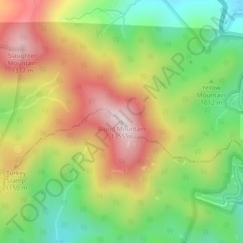
Nom : Carte topographique Blood Mountain, altitude, relief.
Lieu : Blood Mountain, Union County, Georgia, United States (34.73966 -83.93707 34.73976 -83.93697)
Altitude moyenne : 1 048 m
Altitude minimum : 795 m
Altitude maximum : 1 338 m
Faire un don
Équipez-vous pour votre prochaine aventure :
En tant que Partenaire Amazon, ce site perçoit une commission sur les achats éligibles sans surcoût pour vous.
Autres cartes topographiques
Cliquez sur une carte pour visualiser sa topographie, son altitude et son relief.
Blairsville
United States > Georgia > Union County
Blairsville, Georgia, is situated in the picturesque Appalachian Mountains, characterized by a varied topography that includes rolling hills, lush valleys, and prominent mountain ridges. The elevation of the town itself is approximately 1,800 feet, providing breathtaking views of the surrounding landscape. The…
Altitude moyenne : 587 m
Blairsville
United States > Georgia > Union County
Blairsville has a humid subtropical climate, yet due to its elevation of 1,883 feet (574 m), typically records far lower temperatures at night than what is encountered in much of the Southeastern U.S., and has slightly higher precipitation totals (56 inches or 1,420 millimetres annually) than most locations in…
Altitude moyenne : 587 m