
Faire un don
Équipez-vous pour votre prochaine aventure :
En tant que Partenaire Amazon, ce site perçoit une commission sur les achats éligibles sans surcoût pour vous.
Carte topographique Nottely Lake
Cliquez sur la carte pour afficher l’altitude.
Faire un don
Équipez-vous pour votre prochaine aventure :
En tant que Partenaire Amazon, ce site perçoit une commission sur les achats éligibles sans surcoût pour vous.
À propos de cette carte
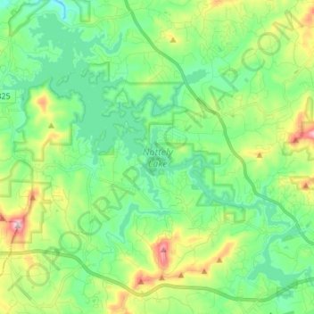
Nom : Carte topographique Nottely Lake, altitude, relief.
Lieu : Nottely Lake, Union County, Georgia, 30512, United States (34.86001 -84.11573 34.96157 -83.98116)
Altitude moyenne : 587 m
Altitude minimum : 490 m
Altitude maximum : 824 m
Faire un don
Équipez-vous pour votre prochaine aventure :
En tant que Partenaire Amazon, ce site perçoit une commission sur les achats éligibles sans surcoût pour vous.
Autres cartes topographiques
Cliquez sur une carte pour visualiser sa topographie, son altitude et son relief.
Blood Mountain
United States > Georgia > Union County
Blood Mountain is the highest peak on the Georgia section of the Appalachian Trail and the sixth-tallest mountain in Georgia, with an elevation of 4,458 feet (1,359 m). It is located on the border of Lumpkin County with Union County and is within the boundaries of the Chattahoochee National Forest and the…
Altitude moyenne : 1 048 m
Faire un don
Équipez-vous pour votre prochaine aventure :
En tant que Partenaire Amazon, ce site perçoit une commission sur les achats éligibles sans surcoût pour vous.