
Faire un don
Équipez-vous pour votre prochaine aventure :
En tant que Partenaire Amazon, ce site perçoit une commission sur les achats éligibles sans surcoût pour vous.
Carte topographique Midsomer Norton
Cliquez sur la carte pour afficher l’altitude.
Faire un don
Équipez-vous pour votre prochaine aventure :
En tant que Partenaire Amazon, ce site perçoit une commission sur les achats éligibles sans surcoût pour vous.
À propos de cette carte
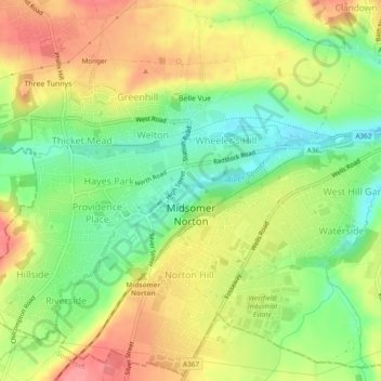
Nom : Carte topographique Midsomer Norton, altitude, relief.
Altitude moyenne : 114 m
Altitude minimum : 73 m
Altitude maximum : 155 m
Faire un don
Équipez-vous pour votre prochaine aventure :
En tant que Partenaire Amazon, ce site perçoit une commission sur les achats éligibles sans surcoût pour vous.
Autres cartes topographiques
Cliquez sur une carte pour visualiser sa topographie, son altitude et son relief.
Hallatrow
United Kingdom > England > Bath and North East Somerset > High Littleton
Altitude moyenne : 119 m
Norton Hawkfield
United Kingdom > England > Bath and North East Somerset > Norton Malreward
Altitude moyenne : 96 m
Faire un don
Équipez-vous pour votre prochaine aventure :
En tant que Partenaire Amazon, ce site perçoit une commission sur les achats éligibles sans surcoût pour vous.
Knowle Hill
United Kingdom > England > Bath and North East Somerset > Chew Magna
Altitude moyenne : 65 m
Little Solsbury Hill
United Kingdom > England > Bath and North East Somerset > Batheaston
Altitude moyenne : 88 m
Bathwick Hill
United Kingdom > England > Bath and North East Somerset > Bath
Number 1 (Bathwick Lodge) is a 2-storey villa with a steep Mansard room, built in 1825, extended in 1840 and the late C19. Probably by John Pinch the Elder.[4] Number 2 is from the early 19th century and has shutters over the windows.[11] Number 3 includes a porch which is elaborately enriched with carving,…
Altitude moyenne : 93 m
North Wick
United Kingdom > England > Bath and North East Somerset > Chew Magna
Altitude moyenne : 110 m
Faire un don
Équipez-vous pour votre prochaine aventure :
En tant que Partenaire Amazon, ce site perçoit une commission sur les achats éligibles sans surcoût pour vous.
Carlingcott
United Kingdom > England > Bath and North East Somerset > Peasedown St. John
Altitude moyenne : 123 m
Pipehouse
United Kingdom > England > Bath and North East Somerset > Hinton Charterhouse
Altitude moyenne : 94 m
Faire un don
Équipez-vous pour votre prochaine aventure :
En tant que Partenaire Amazon, ce site perçoit une commission sur les achats éligibles sans surcoût pour vous.
Keynsham Memorial Park
United Kingdom > England > Bath and North East Somerset > Keynsham
Altitude moyenne : 29 m
Stoney Littleton
United Kingdom > England > Bath and North East Somerset > Shoscombe
Altitude moyenne : 116 m
Faire un don
Équipez-vous pour votre prochaine aventure :
En tant que Partenaire Amazon, ce site perçoit une commission sur les achats éligibles sans surcoût pour vous.
Clutton Hill
United Kingdom > England > Bath and North East Somerset > Farmborough
Altitude moyenne : 133 m
Faire un don
Équipez-vous pour votre prochaine aventure :
En tant que Partenaire Amazon, ce site perçoit une commission sur les achats éligibles sans surcoût pour vous.
Sharpstone
United Kingdom > England > Bath and North East Somerset > Freshford
Altitude moyenne : 93 m
Park Corner
United Kingdom > England > Bath and North East Somerset > Freshford > Park Corner
Altitude moyenne : 93 m
Faire un don
Équipez-vous pour votre prochaine aventure :
En tant que Partenaire Amazon, ce site perçoit une commission sur les achats éligibles sans surcoût pour vous.
Maes Knoll
United Kingdom > England > Bath and North East Somerset > Norton Malreward
Altitude moyenne : 110 m
Wick Green
United Kingdom > England > Bath and North East Somerset > Bishop Sutton
Altitude moyenne : 82 m
Whitley Batts
United Kingdom > England > Bath and North East Somerset > Pensford
Altitude moyenne : 87 m
Faire un don
Équipez-vous pour votre prochaine aventure :
En tant que Partenaire Amazon, ce site perçoit une commission sur les achats éligibles sans surcoût pour vous.
Chewton Keynsham
United Kingdom > England > Bath and North East Somerset > Compton Dando
Altitude moyenne : 57 m
Faire un don
Équipez-vous pour votre prochaine aventure :
En tant que Partenaire Amazon, ce site perçoit une commission sur les achats éligibles sans surcoût pour vous.