
Faire un don
Équipez-vous pour votre prochaine aventure :
En tant que Partenaire Amazon, ce site perçoit une commission sur les achats éligibles sans surcoût pour vous.
Carte topographique Cintruénigo
Cliquez sur la carte pour afficher l’altitude.
Faire un don
Équipez-vous pour votre prochaine aventure :
En tant que Partenaire Amazon, ce site perçoit une commission sur les achats éligibles sans surcoût pour vous.
Cintruénigo
The village of Cintruénigo is situated in the autonomous community of Navarre within the Ribera de Navarra at an altitude of 391 MSL. Its area is of 35.4 km2 and limits to the north and northeast with the municipality of Corella, to the east and south with that of Tudela and to the west with that of Fitero.
Faire un don
Équipez-vous pour votre prochaine aventure :
En tant que Partenaire Amazon, ce site perçoit une commission sur les achats éligibles sans surcoût pour vous.
À propos de cette carte
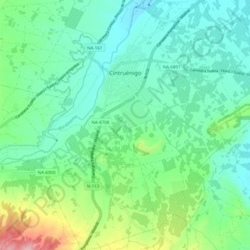
Nom : Carte topographique Cintruénigo, altitude, relief.
Lieu : Cintruénigo, Erribera / Ribera, 31592, Spain (42.02904 -1.83733 42.10075 -1.74355)
Altitude moyenne : 427 m
Altitude minimum : 362 m
Altitude maximum : 628 m
Faire un don
Équipez-vous pour votre prochaine aventure :
En tant que Partenaire Amazon, ce site perçoit une commission sur les achats éligibles sans surcoût pour vous.