
Carte topographique Willey
Cliquez sur la carte pour afficher l’altitude.
À propos de cette carte
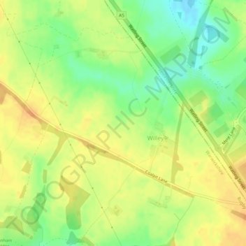
Nom : Carte topographique Willey, altitude, relief.
Lieu : Willey, Warwickshire, England, United Kingdom (52.44931 -1.29861 52.47201 -1.25293)
Altitude moyenne : 123 m
Altitude minimum : 103 m
Altitude maximum : 136 m
Autres cartes topographiques
Cliquez sur une carte pour visualiser sa topographie, son altitude et son relief.
Upper Quinton
United Kingdom > England > Warwickshire > Stratford-on-Avon > Lower Quinton
Altitude moyenne : 70 m
Brook End
United Kingdom > England > Warwickshire > North Warwickshire > Hurley
Altitude moyenne : 107 m
Edgehill
United Kingdom > England > Warwickshire > Stratford-on-Avon > Radway
Altitude moyenne : 157 m
Pillerton Hersey CP
United Kingdom > England > Warwickshire > Stratford-on-Avon
Altitude moyenne : 92 m
Sutton under Brailes
United Kingdom > England > Warwickshire > Stratford-on-Avon
Altitude moyenne : 132 m
Compton Verney CP
United Kingdom > England > Warwickshire > Stratford-on-Avon
Altitude moyenne : 103 m
Rowington Green
United Kingdom > England > Warwickshire > Warwick > Rowington
Altitude moyenne : 114 m
Bidford on Avon CP
United Kingdom > England > Warwickshire > Stratford-on-Avon
Altitude moyenne : 42 m
Stratford-on-Avon
United Kingdom > England > Warwickshire > Stratford-on-Avon
Altitude moyenne : 108 m
Tanworth in Arden CP
United Kingdom > England > Warwickshire > Stratford-on-Avon
Altitude moyenne : 139 m
Warwick
United Kingdom > England > Warwickshire
Warwick experiences the usual English maritime climate, marked by a narrow temperature range, mild winters and cool summers. The nearest official Met Office weather station is at Wellesbourne, about 6 miles (10 km) south of the town centre and at a similar elevation. The absolute maximum temperature (also the…
Altitude moyenne : 87 m
Stratford-upon-Avon
United Kingdom > England > Warwickshire > Stratford-on-Avon
Altitude moyenne : 61 m
Gilson
United Kingdom > England > Warwickshire > North Warwickshire > Coleshill CP
Altitude moyenne : 82 m
Napton on the Hill
United Kingdom > England > Warwickshire > Stratford-on-Avon
Altitude moyenne : 113 m
Brailes
United Kingdom > England > Warwickshire > Stratford-on-Avon > Lower Brailes
Altitude moyenne : 139 m
Hampton on the Hill
United Kingdom > England > Warwickshire > Warwick > Hampton on the Hill
Altitude moyenne : 75 m
Bishops Itchington
United Kingdom > England > Warwickshire > Stratford-on-Avon
Altitude moyenne : 104 m
Birmingham and Fazeley Canal
United Kingdom > England > Warwickshire > Minworth
Altitude moyenne : 105 m
Lye Green
United Kingdom > England > Warwickshire > Stratford-on-Avon > Claverdon
Altitude moyenne : 106 m