
Faire un don
Équipez-vous pour votre prochaine aventure :
En tant que Partenaire Amazon, ce site perçoit une commission sur les achats éligibles sans surcoût pour vous.
Carte topographique Delhi
Cliquez sur la carte pour afficher l’altitude.
Faire un don
Équipez-vous pour votre prochaine aventure :
En tant que Partenaire Amazon, ce site perçoit une commission sur les achats éligibles sans surcoût pour vous.
Delhi
There is a valley that spans a distance of 5 kilometres or 3.1 miles between Delhi and Lynedoch that contains remnants of Ontario's original old-growth Carolinian forest, adding up to just over 1 square mile (2.6 km2). The major highway route connecting this community to Port Talbot was constructed primarily on an old Aboriginal trail. Delhi remained isolated from the rest of Southwestern Ontario until 1816, when Colonel Thomas Talbot directed the surveyor to build the Talbot Trail on higher elevation land to avoid swampy marshland. This decision led to the irregular and winding route to Aylmer that Ontario Highway 3 is today. Most of Delhi was basically a dense forest until the first generation European settlers came in to build farms and mills during the 1820s. Swamps can be seen within the lower elevation portions of the region, while Big Otter Creek is located in close proximity to the downtown core.
Faire un don
Équipez-vous pour votre prochaine aventure :
En tant que Partenaire Amazon, ce site perçoit une commission sur les achats éligibles sans surcoût pour vous.
À propos de cette carte
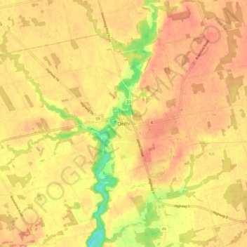
Nom : Carte topographique Delhi, altitude, relief.
Lieu : Delhi, Norfolk County, Ontario, N4B 2K6, Canada (42.81450 -80.53837 42.89450 -80.45837)
Altitude moyenne : 237 m
Altitude minimum : 202 m
Altitude maximum : 250 m
Faire un don
Équipez-vous pour votre prochaine aventure :
En tant que Partenaire Amazon, ce site perçoit une commission sur les achats éligibles sans surcoût pour vous.
Autres cartes topographiques
Cliquez sur une carte pour visualiser sa topographie, son altitude et son relief.
Turkey Point Provincial Park
Canada > Ontario > Norfolk County > Turkey Point
Altitude moyenne : 192 m
Faire un don
Équipez-vous pour votre prochaine aventure :
En tant que Partenaire Amazon, ce site perçoit une commission sur les achats éligibles sans surcoût pour vous.
Faire un don
Équipez-vous pour votre prochaine aventure :
En tant que Partenaire Amazon, ce site perçoit une commission sur les achats éligibles sans surcoût pour vous.