
Faire un don
Équipez-vous pour votre prochaine aventure :
En tant que Partenaire Amazon, ce site perçoit une commission sur les achats éligibles sans surcoût pour vous.
Carte topographique Ob River
Cliquez sur la carte pour afficher l’altitude.
Faire un don
Équipez-vous pour votre prochaine aventure :
En tant que Partenaire Amazon, ce site perçoit une commission sur les achats éligibles sans surcoût pour vous.
Ob River
The combined Ob-Irtysh system, the fourth-longest river system of Asia (after Yenisei, and China's Yangzi and Yellow rivers), is 5,410 kilometres (3,360 mi) long, and the area of its basin 2,990,000 square kilometres (1,150,000 sq mi). The river basin of the Ob consists mostly of steppe, taiga, swamps, tundra, and semi-desert topography. The floodplains of the Ob are characterised by many tributaries and lakes. The Ob is icebound at southern Barnaul from early in November to near the end of April, and at northern Salekhard, 150 km (93 mi) above its mouth, from the end of October to the beginning of June. The Ob River crosses several climatic zones. The upper Ob valley, in the south, supports grapes, melons and watermelons, whereas the lower reaches of the Ob are Arctic tundra. The most temperate climates on the Ob are at Biysk, Barnaul, and Novosibirsk.
Faire un don
Équipez-vous pour votre prochaine aventure :
En tant que Partenaire Amazon, ce site perçoit une commission sur les achats éligibles sans surcoût pour vous.
À propos de cette carte
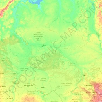
Nom : Carte topographique Ob River, altitude, relief.
Lieu : Ob River, Ural Federal District, Russia (52.30043 65.04695 66.78650 84.97333)
Altitude moyenne : 122 m
Altitude minimum : -1 m
Altitude maximum : 1 948 m
Faire un don
Équipez-vous pour votre prochaine aventure :
En tant que Partenaire Amazon, ce site perçoit une commission sur les achats éligibles sans surcoût pour vous.
Autres cartes topographiques
Cliquez sur une carte pour visualiser sa topographie, son altitude et son relief.
Sochi
Russia > Krasnodar Krai > Resort Town of Sochi (municipal formation)
Sochi has a humid subtropical climate (Köppen climate classification Cfa), at the lower elevations. Its average annual temperature is 18.9 °C (66.0 °F) during the day and 11.5 °C (52.7 °F) at night. In the coldest months—January and February—the average temperature is about 10 °C (50 °F) during the…
Altitude moyenne : 148 m
Mount Elbrus (West Summit)
Russia > Karachay-Cherkessia > Karachayevsky District
As Elbrus is located in the Northern Hemisphere, the summer period takes place from June to mid-September, with an average of 50% of sunny days favorable to the ascent of the summit. However, the winds, dominated by westerly air masses, can turn violent and temperatures drop very quickly. Above 4000 meters…
Altitude moyenne : 5 161 m
Faire un don
Équipez-vous pour votre prochaine aventure :
En tant que Partenaire Amazon, ce site perçoit une commission sur les achats éligibles sans surcoût pour vous.
Ural Mountains
Russia > Khanty-Mansiysk Autonomous Okrug – Ugra > Beryozovsky District
The Ural Mountains (/ˈjʊərəl/ YOOR-əl; Russian: Ура́льские го́ры, tr. Uralskiye gory, IPA: [ʊˈralʲskʲɪjə ˈɡorɨ]; Bashkir: Урал тауҙары) or simply the Urals, are a mountain range in Eurasia that runs north-south mostly through Russia, from the coast of the Arctic Ocean to…
Altitude moyenne : 1 435 m
Faire un don
Équipez-vous pour votre prochaine aventure :
En tant que Partenaire Amazon, ce site perçoit une commission sur les achats éligibles sans surcoût pour vous.
Siberia
Russia > Krasnoyarsk Krai > Boguchansky Rayon
Eastern and central Sakha comprises numerous north–south mountain ranges of various ages. These mountains extend up to almost 3,000 metres (9,800 ft), but above a few hundred metres they are almost completely devoid of vegetation. The Verkhoyansk Range was extensively glaciated in the Pleistocene, but the…
Altitude moyenne : 346 m
Dzhugdzhur Mountains
Russia > Khabarovsk Krai > Ayano-Maysky Rayon
The coastal stretch of the range is populated by Japanese stone pine and Dahurian larch. Parts of the range occupied by the Okhotsk-Manchurian taiga ecoregion contain swathes of Jezo spruce up to elevations of 1,300 m.
Altitude moyenne : 1 564 m
Faire un don
Équipez-vous pour votre prochaine aventure :
En tant que Partenaire Amazon, ce site perçoit une commission sur les achats éligibles sans surcoût pour vous.
Verkhoyansk
Russia > Sakha Republic > Verkhoyansky Ulus
In this area, temperature inversions consistently form in winter due to the extremely cold and dense air of the Siberian High pooling in deep hollows, so that temperatures increase rather than decrease with higher altitude. In Verkhoyansk it sometimes happens that the average minimum temperatures for January,…
Altitude moyenne : 140 m
Faire un don
Équipez-vous pour votre prochaine aventure :
En tant que Partenaire Amazon, ce site perçoit une commission sur les achats éligibles sans surcoût pour vous.
Faire un don
Équipez-vous pour votre prochaine aventure :
En tant que Partenaire Amazon, ce site perçoit une commission sur les achats éligibles sans surcoût pour vous.
Faire un don
Équipez-vous pour votre prochaine aventure :
En tant que Partenaire Amazon, ce site perçoit une commission sur les achats éligibles sans surcoût pour vous.
Faire un don
Équipez-vous pour votre prochaine aventure :
En tant que Partenaire Amazon, ce site perçoit une commission sur les achats éligibles sans surcoût pour vous.
Faire un don
Équipez-vous pour votre prochaine aventure :
En tant que Partenaire Amazon, ce site perçoit une commission sur les achats éligibles sans surcoût pour vous.
Lokosovo
Russia > Khanty-Mansiysk Autonomous Okrug – Ugra > Surgutsky District
Altitude moyenne : 42 m
Тюли
Russia > Khanty-Mansiysk Autonomous Okrug – Ugra > Khanty-Mansiysky District
Altitude moyenne : 27 m
Faire un don
Équipez-vous pour votre prochaine aventure :
En tant que Partenaire Amazon, ce site perçoit une commission sur les achats éligibles sans surcoût pour vous.
Kruzenshtern
Russia > Arkhangelsk Oblast > Novaya Zemlya Urban Okrug
The mountain was first put on the map in the 1820s by Arctic explorer Fyodor Litke (1797–1882) following his Novaya Zemlya explorations. It was named after Imperial Russian Navy Admiral Ivan Kruzenshtern (1770–1846). The mountain's name must have been known to Soviet topographers, but for undisclosed…
Altitude moyenne : 1 046 m
Faire un don
Équipez-vous pour votre prochaine aventure :
En tant que Partenaire Amazon, ce site perçoit une commission sur les achats éligibles sans surcoût pour vous.
Mount Yamantau
Russia > Bashkortostan > Beloretsky District
Up to 1,000–1,100 m elevation, the mountain slope is covered with mixed forest, in some places with driftwood, occasional alpine meadows and rocky outcrops. Above 1,100 m elevation, there are no trees or bushes, and instead rock streams of various sizes, with grass, flowers and moss start to appear.
Altitude moyenne : 1 334 m
Faire un don
Équipez-vous pour votre prochaine aventure :
En tant que Partenaire Amazon, ce site perçoit une commission sur les achats éligibles sans surcoût pour vous.
Faire un don
Équipez-vous pour votre prochaine aventure :
En tant que Partenaire Amazon, ce site perçoit une commission sur les achats éligibles sans surcoût pour vous.
Faire un don
Équipez-vous pour votre prochaine aventure :
En tant que Partenaire Amazon, ce site perçoit une commission sur les achats éligibles sans surcoût pour vous.
Faire un don
Équipez-vous pour votre prochaine aventure :
En tant que Partenaire Amazon, ce site perçoit une commission sur les achats éligibles sans surcoût pour vous.
озеро Коробейниково
Russia > Sverdlovsk Oblast > Тавдинский муниципальный округ > Азанка
Altitude moyenne : 72 m
Faire un don
Équipez-vous pour votre prochaine aventure :
En tant que Partenaire Amazon, ce site perçoit une commission sur les achats éligibles sans surcoût pour vous.
Oymyakon
Russia > Sakha Republic > Oymyakonsky Ulus
With an extreme subarctic climate (Köppen climate classification Dfd, Trewartha climate classification Ecle), Oymyakon is known as one of the places considered the Northern Pole of Cold, the other being the town of Verkhoyansk, located 629 km (391 mi) away by air. The weather station is in a valley between…
Altitude moyenne : 679 m
Faire un don
Équipez-vous pour votre prochaine aventure :
En tant que Partenaire Amazon, ce site perçoit une commission sur les achats éligibles sans surcoût pour vous.
Faire un don
Équipez-vous pour votre prochaine aventure :
En tant que Partenaire Amazon, ce site perçoit une commission sur les achats éligibles sans surcoût pour vous.
Mount Yamantau
Russia > Bashkortostan > Beloretsky District
Up to 1,000–1,100 m elevation, the mountain slope is covered with mixed forest, in some places with driftwood, occasional alpine meadows and rocky outcrops. Above 1,100 m elevation, there are no trees or bushes, and instead rock streams of various sizes, with grass, flowers and moss start to appear.
Altitude moyenne : 1 334 m
Faire un don
Équipez-vous pour votre prochaine aventure :
En tant que Partenaire Amazon, ce site perçoit une commission sur les achats éligibles sans surcoût pour vous.
Shkhara
Russia > Kabardino-Balkaria > Cherek District > Verkhnyaya Balkariya
Altitude moyenne : 4 355 m
Faire un don
Équipez-vous pour votre prochaine aventure :
En tant que Partenaire Amazon, ce site perçoit une commission sur les achats éligibles sans surcoût pour vous.
Faire un don
Équipez-vous pour votre prochaine aventure :
En tant que Partenaire Amazon, ce site perçoit une commission sur les achats éligibles sans surcoût pour vous.
Faire un don
Équipez-vous pour votre prochaine aventure :
En tant que Partenaire Amazon, ce site perçoit une commission sur les achats éligibles sans surcoût pour vous.
Faire un don
Équipez-vous pour votre prochaine aventure :
En tant que Partenaire Amazon, ce site perçoit une commission sur les achats éligibles sans surcoût pour vous.
Tyulyuk River
Russia > Chelyabinsk Oblast > Katav-Ivanovsky District > Tyulyuk
Altitude moyenne : 675 m
Faire un don
Équipez-vous pour votre prochaine aventure :
En tant que Partenaire Amazon, ce site perçoit une commission sur les achats éligibles sans surcoût pour vous.
Tunguska event
Russia > Krasnoyarsk Krai > Evenkiysky Rayon
The Tunguska event was a large explosion of between 3 and 50 megatons that occurred near the Podkamennaya Tunguska River in Yeniseysk Governorate (now Krasnoyarsk Krai), Russia, on the morning of 30 June 1908. The explosion over the sparsely populated East Siberian taiga felled a large number of trees, over an…
Altitude moyenne : 333 m
Faire un don
Équipez-vous pour votre prochaine aventure :
En tant que Partenaire Amazon, ce site perçoit une commission sur les achats éligibles sans surcoût pour vous.
Faire un don
Équipez-vous pour votre prochaine aventure :
En tant que Partenaire Amazon, ce site perçoit une commission sur les achats éligibles sans surcoût pour vous.