
Carte topographique Meltham
Cliquez sur la carte pour afficher l’altitude.
À propos de cette carte
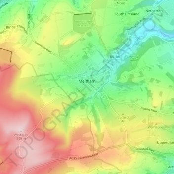
Nom : Carte topographique Meltham, altitude, relief.
Lieu : Meltham, Kirklees, West Yorkshire, England, United Kingdom (53.56447 -1.90694 53.61519 -1.81310)
Altitude moyenne : 278 m
Altitude minimum : 106 m
Altitude maximum : 497 m
Autres cartes topographiques
Cliquez sur une carte pour visualiser sa topographie, son altitude et son relief.
Slaithwaite
United Kingdom > England > Kirklees
In the 1848 edition of 'A Topographical Dictionary of England', Samuel Lewis (the editor) wrote:- "the lands are in meadow and pasture, with a small portion of arable; the scenery is bold and romantic. In the quarries of the district are found vegetable fossils, especially firs and other mountain trees. The…
Altitude moyenne : 241 m
Clayton West
United Kingdom > England > Kirklees
Listed as Clayton, West, the village featured in "A Topographical Dictionary of England" which was published by Samuel Lewis, London, 1848. In 1848 the village had 1440 residents and was described as being 1080 acres belonging to various owners. Mining was listed as the predominant industry, along with the…
Altitude moyenne : 150 m