
Faire un don
Équipez-vous pour votre prochaine aventure :
En tant que Partenaire Amazon, ce site perçoit une commission sur les achats éligibles sans surcoût pour vous.
Carte topographique Findlay
Cliquez sur la carte pour afficher l’altitude.
Faire un don
Équipez-vous pour votre prochaine aventure :
En tant que Partenaire Amazon, ce site perçoit une commission sur les achats éligibles sans surcoût pour vous.
Findlay
Findlay is situated on relatively flat terrain within the northwest region of the state, characterized by gently rolling hills and fertile plains. The city lies at an elevation of approximately 800 feet (244 meters) above sea level, with the Blanchard River meandering through the area, contributing to the landscape's gentle undulations. The surrounding region features rich agricultural land, making it well-suited for farming, while nearby woodlands and small parks provide pockets of natural beauty. This topography, combined with the river's proximity, creates a picturesque environment that supports both urban development and outdoor recreational opportunities.
Faire un don
Équipez-vous pour votre prochaine aventure :
En tant que Partenaire Amazon, ce site perçoit une commission sur les achats éligibles sans surcoût pour vous.
À propos de cette carte
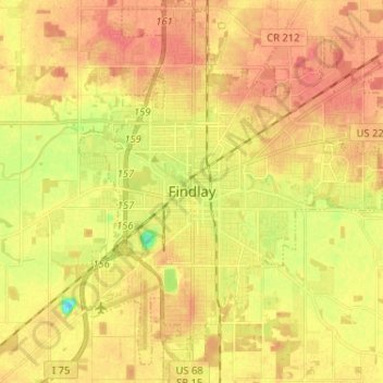
Nom : Carte topographique Findlay, altitude, relief.
Lieu : Findlay, Hancock County, Ohio, United States (40.99265 -83.68940 41.08993 -83.57347)
Altitude moyenne : 243 m
Altitude minimum : 211 m
Altitude maximum : 261 m
Faire un don
Équipez-vous pour votre prochaine aventure :
En tant que Partenaire Amazon, ce site perçoit une commission sur les achats éligibles sans surcoût pour vous.
Autres cartes topographiques
Cliquez sur une carte pour visualiser sa topographie, son altitude et son relief.