
Faire un don
Équipez-vous pour votre prochaine aventure :
En tant que Partenaire Amazon, ce site perçoit une commission sur les achats éligibles sans surcoût pour vous.
Carte topographique Williamstown
Cliquez sur la carte pour afficher l’altitude.
Faire un don
Équipez-vous pour votre prochaine aventure :
En tant que Partenaire Amazon, ce site perçoit une commission sur les achats éligibles sans surcoût pour vous.
À propos de cette carte
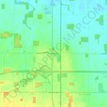
Nom : Carte topographique Williamstown, altitude, relief.
Lieu : Williamstown, Hancock County, Ohio, 45897, United States (40.81394 -83.67076 40.85394 -83.63076)
Altitude moyenne : 283 m
Altitude minimum : 271 m
Altitude maximum : 300 m
Faire un don
Équipez-vous pour votre prochaine aventure :
En tant que Partenaire Amazon, ce site perçoit une commission sur les achats éligibles sans surcoût pour vous.
Autres cartes topographiques
Cliquez sur une carte pour visualiser sa topographie, son altitude et son relief.
Findlay
United States > Ohio > Hancock County
Findlay is situated on relatively flat terrain within the northwest region of the state, characterized by gently rolling hills and fertile plains. The city lies at an elevation of approximately 800 feet (244 meters) above sea level, with the Blanchard River meandering through the area, contributing to the…
Altitude moyenne : 243 m