
Carte topographique Mount Ball
Cliquez sur la carte pour afficher l’altitude.
À propos de cette carte
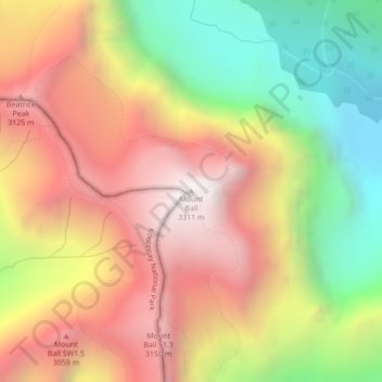
Nom : Carte topographique Mount Ball, altitude, relief.
Lieu : Mount Ball, Improvement District No. 9, Alberta, Canada (51.15605 -116.00725 51.15615 -116.00715)
Altitude moyenne : 2 621 m
Altitude minimum : 1 883 m
Altitude maximum : 3 278 m
Autres cartes topographiques
Cliquez sur une carte pour visualiser sa topographie, son altitude et son relief.
Moraine Lake
Canada > Alberta > Improvement District No. 9
Moraine Lake is a snow and glacially fed alpine lake in Banff National Park, 14 kilometres (8.7 mi) outside the village of Lake Louise, Alberta, Canada. It is situated in the Valley of the Ten Peaks, at an elevation of approximately 1,884 metres (6,181 ft). The lake has a surface area of 50 hectares (120…
Altitude moyenne : 2 101 m
Peyto Glacier
Canada > Alberta > Improvement District No. 9 > Area A (Kicking Horse/Kinbasket Lake)
Altitude moyenne : 2 641 m
Johnston Creek
Canada > Alberta > Improvement District No. 9
Johnston Creek originates north of Castle Mountain in a glacial valley southwest of Badger Pass and south of Pulsatilla Pass, at an elevation of 2,500 meters (8,200 ft). The creek flows southeast between Helena Ridge and the Sawback Range, and then south through a gorge known as Johnston Canyon. The stream…
Altitude moyenne : 2 135 m
Moraine Lake
Canada > Alberta > Improvement District No. 9
Moraine Lake is a snow and glacially fed alpine lake in Banff National Park, 14 kilometres (8.7 mi) outside the village of Lake Louise, Alberta, Canada. It is situated in the Valley of the Ten Peaks, at an elevation of approximately 1,884 metres (6,181 ft). The lake has a surface area of 50 hectares (120…
Altitude moyenne : 2 101 m
Johnston Creek
Canada > Alberta > Improvement District No. 9
Johnston Creek originates north of Castle Mountain in a glacial valley southwest of Badger Pass and south of Pulsatilla Pass, at an elevation of 2,500 meters (8,200 ft). The creek flows southeast between Helena Ridge and the Sawback Range, and then south through a gorge known as Johnston Canyon. The stream…
Altitude moyenne : 2 135 m