
Carte topographique Village of Millbrook
Carte interactive
Cliquez sur la carte pour afficher l’altitude.
À propos de cette carte
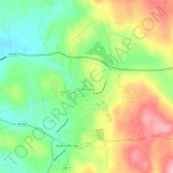
Nom : Carte topographique Village of Millbrook, altitude, relief.
Altitude moyenne : 196 m
Altitude minimum : 130 m
Altitude maximum : 279 m
Autres cartes topographiques
Cliquez sur une carte pour visualiser sa topographie, son altitude et son relief.
Hopewell Junction
United States > New York > Dutchess County > Town of East Fishkill
Hopewell Junction, Town of East Fishkill, Dutchess County, New York, United States
Altitude moyenne : 83 m
Rhinecliff
United States > New York > Dutchess County > Town of Rhinebeck
Rhinecliff, Town of Rhinebeck, Dutchess County, New York, 12574, United States
Altitude moyenne : 19 m
Town of La Grange
United States > New York > Dutchess County
Town of La Grange, Dutchess County, New York, 12540, United States
Altitude moyenne : 118 m
Town of Fishkill
United States > New York > Dutchess County
Town of Fishkill, Dutchess County, New York, United States
Altitude moyenne : 178 m
Town of Hyde Park
United States > New York > Dutchess County
Town of Hyde Park, Dutchess County, New York, United States
Altitude moyenne : 93 m
Town of Washington
United States > New York > Dutchess County
Town of Washington, Dutchess County, New York, 12545, United States
Altitude moyenne : 225 m
Village of Millerton
United States > New York > Dutchess County
Village of Millerton, Town of North East, Dutchess County, New York, United States
Altitude moyenne : 243 m
Staatsburg
United States > New York > Dutchess County > Town of Hyde Park
Staatsburg, Town of Hyde Park, Dutchess County, New York, United States
Altitude moyenne : 25 m
Town of North East
United States > New York > Dutchess County
Town of North East, Dutchess County, New York, 12546, United States
Altitude moyenne : 267 m
Town of Pleasant Valley
United States > New York > Dutchess County
Town of Pleasant Valley, Dutchess County, New York, United States
Altitude moyenne : 112 m
Village of Fishkill
United States > New York > Dutchess County
Village of Fishkill, Town of Fishkill, Dutchess County, New York, 12524, United States
Altitude moyenne : 75 m
Glenham
United States > New York > Dutchess County > Town of Fishkill
Glenham, Town of Fishkill, Dutchess County, New York, 12527, United States
Altitude moyenne : 108 m
State Line
United States > New York > Dutchess County > State Line
State Line, Town of North East, Dutchess County, New York, 12546, United States
Altitude moyenne : 268 m
Beacon
United States > New York > Dutchess County > Beacon > Beacon
Beacon, Dutchess County, New York, 12508, United States
Altitude moyenne : 91 m
Town of Red Hook
United States > New York > Dutchess County > Town of Red Hook
Town of Red Hook, Dutchess County, New York, United States
Altitude moyenne : 62 m
Stanfordville
United States > New York > Dutchess County
Stanfordville, Town of Stanford, Dutchess County, New York, 12506, United States
Altitude moyenne : 137 m
Pine Plains CDP
United States > New York > Dutchess County
Pine Plains CDP, Dutchess County, New York, 12567, United States
Altitude moyenne : 149 m
City of Beacon
United States > New York > Dutchess County
City of Beacon, Dutchess County, New York, 12508, United States
Altitude moyenne : 68 m
Hurd Corners
United States > New York > Dutchess County > Town of Pawling
Hurd Corners, Town of Pawling, Dutchess County, New York, 12564, United States
Altitude moyenne : 199 m