
Carte topographique Town of North East
Carte interactive
Cliquez sur la carte pour afficher l’altitude.
À propos de cette carte
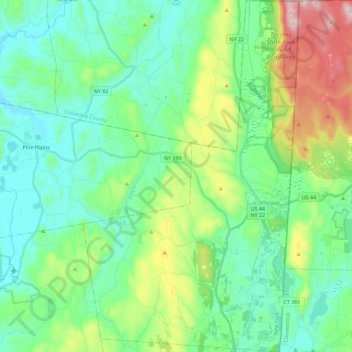
Nom : Carte topographique Town of North East, altitude, relief.
Altitude moyenne : 267 m
Altitude minimum : 116 m
Altitude maximum : 715 m
Brace Mountain's 2,311-foot (704 m) summit, near the Connecticut state line in the northeastern corner of town, is the highest point in Dutchess County. The lowest elevation is 530 feet (160 m), along Shekomeko Creek at the Pine Plains town line.
Autres cartes topographiques
Cliquez sur une carte pour visualiser sa topographie, son altitude et son relief.
Hopewell Junction
United States > New York > Dutchess County > Town of East Fishkill
Hopewell Junction, Town of East Fishkill, Dutchess County, New York, United States
Altitude moyenne : 83 m
Rhinecliff
United States > New York > Dutchess County > Town of Rhinebeck
Rhinecliff, Town of Rhinebeck, Dutchess County, New York, 12574, United States
Altitude moyenne : 19 m
Town of La Grange
United States > New York > Dutchess County
Town of La Grange, Dutchess County, New York, 12540, United States
Altitude moyenne : 118 m
Town of Fishkill
United States > New York > Dutchess County
Town of Fishkill, Dutchess County, New York, United States
Altitude moyenne : 178 m
Town of Hyde Park
United States > New York > Dutchess County
Town of Hyde Park, Dutchess County, New York, United States
Altitude moyenne : 93 m
Town of Washington
United States > New York > Dutchess County
Town of Washington, Dutchess County, New York, 12545, United States
Altitude moyenne : 225 m
Village of Millerton
United States > New York > Dutchess County
Village of Millerton, Town of North East, Dutchess County, New York, United States
Altitude moyenne : 243 m
Staatsburg
United States > New York > Dutchess County > Town of Hyde Park
Staatsburg, Town of Hyde Park, Dutchess County, New York, United States
Altitude moyenne : 25 m
Town of Pleasant Valley
United States > New York > Dutchess County
Town of Pleasant Valley, Dutchess County, New York, United States
Altitude moyenne : 112 m
Village of Fishkill
United States > New York > Dutchess County
Village of Fishkill, Town of Fishkill, Dutchess County, New York, 12524, United States
Altitude moyenne : 75 m
Glenham
United States > New York > Dutchess County > Town of Fishkill
Glenham, Town of Fishkill, Dutchess County, New York, 12527, United States
Altitude moyenne : 108 m
State Line
United States > New York > Dutchess County > State Line
State Line, Town of North East, Dutchess County, New York, 12546, United States
Altitude moyenne : 268 m
Beacon
United States > New York > Dutchess County > Beacon > Beacon
Beacon, Dutchess County, New York, 12508, United States
Altitude moyenne : 91 m
Town of Red Hook
United States > New York > Dutchess County > Town of Red Hook
Town of Red Hook, Dutchess County, New York, United States
Altitude moyenne : 62 m
Stanfordville
United States > New York > Dutchess County
Stanfordville, Town of Stanford, Dutchess County, New York, 12506, United States
Altitude moyenne : 137 m
Pine Plains CDP
United States > New York > Dutchess County
Pine Plains CDP, Dutchess County, New York, 12567, United States
Altitude moyenne : 149 m
City of Beacon
United States > New York > Dutchess County
City of Beacon, Dutchess County, New York, 12508, United States
Altitude moyenne : 68 m
Hurd Corners
United States > New York > Dutchess County > Town of Pawling
Hurd Corners, Town of Pawling, Dutchess County, New York, 12564, United States
Altitude moyenne : 199 m
Village of Millbrook
United States > New York > Dutchess County
Village of Millbrook, Town of Washington, Dutchess County, New York, 12545, United States
Altitude moyenne : 196 m