
Carte topographique Mull
Cliquez sur la carte pour afficher l’altitude.
À propos de cette carte
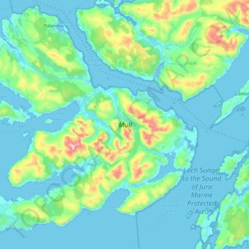
Nom : Carte topographique Mull, altitude, relief.
Lieu : Mull, Argyll and Bute, Scotland, United Kingdom (56.26284 -6.38584 56.65635 -5.64567)
Altitude moyenne : 122 m
Altitude minimum : -2 m
Altitude maximum : 960 m
Autres cartes topographiques
Cliquez sur une carte pour visualiser sa topographie, son altitude et son relief.
Strachur
United Kingdom > Scotland > Argyll and Bute
The area around Strachur borders the Loch Lomond and the Trossachs National Park. The parish is bounded along its north-west side by Loch Fyne - Strachur forming its north-western district, and Strathlachlan its south-western one; and it is bounded on other sides by the parishes of Lochgoilhead, Kilmun,…
Altitude moyenne : 125 m
Ben More
United Kingdom > Scotland > Argyll and Bute
Ben More (Scottish Gaelic: Beinn Mhòr, meaning "great mountain") is the highest mountain and only Munro (mountains in Scotland that reach an elevation of at least 3,000 feet or 914.4 metres) on the Isle of Mull, Scotland. It is also the highest peak in the Scottish isles – and the only Munro – apart from…
Altitude moyenne : 574 m
Castle Sween
United Kingdom > Scotland > Argyll and Bute > Achnamara > Kilmichael of Inverlussa
Altitude moyenne : 55 m
Minard Castle
United Kingdom > Scotland > Argyll and Bute > Minard > Tullochgorm
Altitude moyenne : 34 m