Géolocaliser

Carte topographique Loch Dochard

Cliquez sur la carte pour afficher l’altitude.

À propos de cette carte

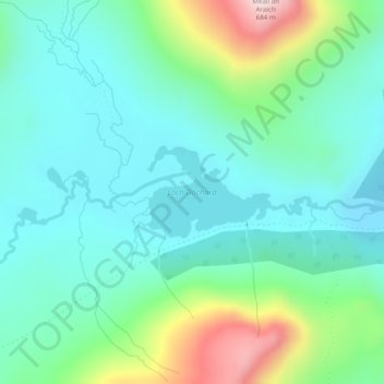
Nom : Carte topographique Loch Dochard, altitude, relief.

Lieu : Loch Dochard, Argyll and Bute, Scotland, United Kingdom (56.53303 -4.91513 56.53954 -4.89930)

Altitude moyenne : 318 m

Altitude minimum : 203 m

Altitude maximum : 673 m

Autres cartes topographiques

Cliquez sur une carte pour visualiser sa topographie, son altitude et son relief.

Islay

United Kingdom > Scotland > Argyll and Bute

Altitude moyenne : 53 m

Bute

United Kingdom > Scotland > Argyll and Bute > Ardbeg

Altitude moyenne : 41 m

Garelochhead

United Kingdom > Scotland > Argyll and Bute

Altitude moyenne : 110 m

Loch Tulla

United Kingdom > Scotland > Argyll and Bute

Altitude moyenne : 210 m

Helensburgh

United Kingdom > Scotland > Argyll and Bute

Altitude moyenne : 63 m

Oban

United Kingdom > Scotland > Argyll and Bute

Altitude moyenne : 52 m

Scalasaig

United Kingdom > Scotland > Argyll and Bute

Altitude moyenne : 30 m

Dunoon

United Kingdom > Scotland > Argyll and Bute

Altitude moyenne : 98 m

Ben Cruachan

United Kingdom > Scotland > Argyll and Bute

Altitude moyenne : 721 m

Beinn Dubh

United Kingdom > Scotland > Argyll and Bute

Altitude moyenne : 470 m

Loch Awe

United Kingdom > Scotland > Argyll and Bute > Lochawe

Altitude moyenne : 218 m

Peaton

United Kingdom > Scotland > Argyll and Bute

Altitude moyenne : 66 m

Tiree

United Kingdom > Scotland > Argyll and Bute > Balemartine

Altitude moyenne : 3 m

Colintraive

United Kingdom > Scotland > Argyll and Bute

Altitude moyenne : 122 m

Muasdale

United Kingdom > Scotland > Argyll and Bute

Altitude moyenne : 62 m

Mull

United Kingdom > Scotland > Argyll and Bute

Altitude moyenne : 122 m

Mannal

United Kingdom > Scotland > Argyll and Bute > Balemartine

Altitude moyenne : 13 m

Colonsay

United Kingdom > Scotland > Argyll and Bute > Scalasaig

Altitude moyenne : 11 m

Blairmore

United Kingdom > Scotland > Argyll and Bute

Altitude moyenne : 61 m

Port Lamont

United Kingdom > Scotland > Argyll and Bute

Altitude moyenne : 42 m

Bunessan

United Kingdom > Scotland > Argyll and Bute

Altitude moyenne : 32 m

Campbeltown

United Kingdom > Scotland > Argyll and Bute

Altitude moyenne : 84 m

Carn

United Kingdom > Scotland > Argyll and Bute > Port Charlotte

Altitude moyenne : 27 m

Tayinloan

United Kingdom > Scotland > Argyll and Bute

Altitude moyenne : 64 m

Crackaig

United Kingdom > Scotland > Argyll and Bute > Craighouse

Altitude moyenne : 39 m

The Slate

United Kingdom > Scotland > Argyll and Bute

Altitude moyenne : 242 m

Ardkinglas

United Kingdom > Scotland > Argyll and Bute > Cairndow

Altitude moyenne : 172 m

Succoth

United Kingdom > Scotland > Argyll and Bute

Altitude moyenne : 235 m

Carradale

United Kingdom > Scotland > Argyll and Bute

Altitude moyenne : 37 m

Ormsary

United Kingdom > Scotland > Argyll and Bute

Altitude moyenne : 70 m

Tullochgorm

United Kingdom > Scotland > Argyll and Bute > Minard

Altitude moyenne : 82 m

Strachur

United Kingdom > Scotland > Argyll and Bute

The area around Strachur borders the Loch Lomond and the Trossachs National Park. The parish is bounded along its north-west side by Loch Fyne - Strachur forming its north-western district, and Strathlachlan its south-western one; and it is bounded on other sides by the parishes of Lochgoilhead, Kilmun,…

Altitude moyenne : 125 m

Kames

United Kingdom > Scotland > Argyll and Bute

Altitude moyenne : 56 m

Loch Etive

United Kingdom > Scotland > Argyll and Bute > Connel

Altitude moyenne : 318 m

Ben More

United Kingdom > Scotland > Argyll and Bute

Ben More (Scottish Gaelic: Beinn Mhòr, meaning "great mountain") is the highest mountain and only Munro (mountains in Scotland that reach an elevation of at least 3,000 feet or 914.4 metres) on the Isle of Mull, Scotland. It is also the highest peak in the Scottish isles – and the only Munro – apart from…

Altitude moyenne : 574 m

Cairnbaan

United Kingdom > Scotland > Argyll and Bute

Altitude moyenne : 68 m

Beinn Bhàn

United Kingdom > Scotland > Argyll and Bute

Altitude moyenne : 162 m

Airds Bay

United Kingdom > Scotland > Argyll and Bute > Taynuilt

Altitude moyenne : 43 m

Lochbuie

United Kingdom > Scotland > Argyll and Bute

Altitude moyenne : 119 m

Saddell

United Kingdom > Scotland > Argyll and Bute

Altitude moyenne : 89 m

Port Askaig

United Kingdom > Scotland > Argyll and Bute

Altitude moyenne : 45 m

Ascog

United Kingdom > Scotland > Argyll and Bute

Altitude moyenne : 22 m

Toberonochy

United Kingdom > Scotland > Argyll and Bute

Altitude moyenne : 15 m

Clachan

United Kingdom > Scotland > Argyll and Bute

Altitude moyenne : 75 m

Cullipool

United Kingdom > Scotland > Argyll and Bute

Altitude moyenne : 12 m

Strone

United Kingdom > Scotland > Argyll and Bute

Altitude moyenne : 58 m

Loch Long

United Kingdom > Scotland > Argyll and Bute > Ardentinny

Altitude moyenne : 238 m

Glenfyne

United Kingdom > Scotland > Argyll and Bute

Altitude moyenne : 328 m

Leanach

United Kingdom > Scotland > Argyll and Bute

Altitude moyenne : 131 m

Portnahaven

United Kingdom > Scotland > Argyll and Bute

Altitude moyenne : 13 m

Kilchoman

United Kingdom > Scotland > Argyll and Bute

Altitude moyenne : 48 m

Ardfin

United Kingdom > Scotland > Argyll and Bute

Altitude moyenne : 57 m

Machrimore

United Kingdom > Scotland > Argyll and Bute > Southend

Altitude moyenne : 38 m

Lochgilphead

United Kingdom > Scotland > Argyll and Bute

Altitude moyenne : 102 m

Ford

United Kingdom > Scotland > Argyll and Bute

Altitude moyenne : 125 m

Bridge of Awe

United Kingdom > Scotland > Argyll and Bute

Altitude moyenne : 237 m

Loch Fyne

United Kingdom > Scotland > Argyll and Bute > Inveraray

Altitude moyenne : 137 m

Taynuilt

United Kingdom > Scotland > Argyll and Bute

Altitude moyenne : 49 m

Craobh Haven

United Kingdom > Scotland > Argyll and Bute

Altitude moyenne : 38 m

Fearnoch

United Kingdom > Scotland > Argyll and Bute

Altitude moyenne : 67 m

Easdale

United Kingdom > Scotland > Argyll and Bute > Easdale

Altitude moyenne : 8 m

Dalmally

United Kingdom > Scotland > Argyll and Bute

Altitude moyenne : 142 m

Lochawe

United Kingdom > Scotland > Argyll and Bute

Altitude moyenne : 198 m

Rothesay

United Kingdom > Scotland > Argyll and Bute

Altitude moyenne : 38 m

Beinn Reithe

United Kingdom > Scotland > Argyll and Bute

Altitude moyenne : 382 m

Stob Dearg

United Kingdom > Scotland > Argyll and Bute

Altitude moyenne : 718 m

Seil

United Kingdom > Scotland > Argyll and Bute > Clachan-Seil

Altitude moyenne : 16 m

Loch Gair

United Kingdom > Scotland > Argyll and Bute > Lochgair

Altitude moyenne : 44 m

Lismore

United Kingdom > Scotland > Argyll and Bute > Achnacroish

The island of Lismore lies in Loch Linnhe, north east of Mull, in the Argyll and Bute council area. It is 15 kilometres (9.3 mi) long and about 2 kilometres (1.2 mi) wide and oriented from SW to NE, roughly parallel to the Great Glen Fault. To the east is an arm of Loch Linnhe known as the Lynn of Lorn.…

Altitude moyenne : 16 m

Dunadd

United Kingdom > Scotland > Argyll and Bute

Altitude moyenne : 20 m

Balliemore

United Kingdom > Scotland > Argyll and Bute

Altitude moyenne : 45 m

Appin

United Kingdom > Scotland > Argyll and Bute

Altitude moyenne : 93 m

Auchendennan

United Kingdom > Scotland > Argyll and Bute

Altitude moyenne : 73 m

Connel

United Kingdom > Scotland > Argyll and Bute

Altitude moyenne : 23 m

Dalavich

United Kingdom > Scotland > Argyll and Bute

Altitude moyenne : 93 m

Beinn Dorain

United Kingdom > Scotland > Argyll and Bute

Altitude moyenne : 579 m

Tarbert

United Kingdom > Scotland > Argyll and Bute

Altitude moyenne : 69 m

Imeraval

United Kingdom > Scotland > Argyll and Bute > Port Ellen

Altitude moyenne : 34 m

Coulport

United Kingdom > Scotland > Argyll and Bute

Altitude moyenne : 61 m

Crossaig

United Kingdom > Scotland > Argyll and Bute

Altitude moyenne : 72 m

Tobermory

United Kingdom > Scotland > Argyll and Bute

Altitude moyenne : 58 m

Lagavulin

United Kingdom > Scotland > Argyll and Bute

Altitude moyenne : 25 m

Knockderry

United Kingdom > Scotland > Argyll and Bute

Altitude moyenne : 75 m

Heanish

United Kingdom > Scotland > Argyll and Bute > Scarinish

Altitude moyenne : 2 m

Coll

United Kingdom > Scotland > Argyll and Bute > Arinagour

Altitude moyenne : 7 m

Luss

United Kingdom > Scotland > Argyll and Bute

Altitude moyenne : 97 m

Edendonich

United Kingdom > Scotland > Argyll and Bute > Dalmally

Altitude moyenne : 149 m

Portincaple

United Kingdom > Scotland > Argyll and Bute

Altitude moyenne : 100 m

Cladich

United Kingdom > Scotland > Argyll and Bute

Altitude moyenne : 119 m

Ben Vorlich

United Kingdom > Scotland > Argyll and Bute

Altitude moyenne : 576 m

Tom Buidhe

United Kingdom > Scotland > Argyll and Bute

Altitude moyenne : 218 m

Ben Vane

United Kingdom > Scotland > Argyll and Bute

Altitude moyenne : 494 m

Beinn Narnain

United Kingdom > Scotland > Argyll and Bute

Altitude moyenne : 615 m

Équipez-vous pour votre prochaine aventure :

🧤Gants de Randonnée - Gants légers et tactiles pour manipuler vos cartes par temps froid.
🔦Lampes frontales - Éclairage mains libres pour marche nocturne et bivouac
🧢Tours de cou multifonctions - Protection contre froid et vent
🕶️Lunettes Polarisées - Protection UV et réduction des reflets pour une vision claire.
🧯Couvertures de survie - Protection thermique d’urgence

En tant que Partenaire Amazon, ce site perçoit une commission sur les achats éligibles sans surcoût pour vous.