
Carte topographique Forgue
Cliquez sur la carte pour afficher l’altitude.
À propos de cette carte
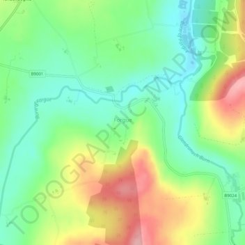
Nom : Carte topographique Forgue, altitude, relief.
Lieu : Forgue, Aberdeenshire, Scotland, United Kingdom (57.48651 -2.65651 57.49486 -2.64591)
Altitude moyenne : 113 m
Altitude minimum : 61 m
Altitude maximum : 196 m
Autres cartes topographiques
Cliquez sur une carte pour visualiser sa topographie, son altitude et son relief.
Braemar
United Kingdom > Scotland > Aberdeenshire
Braemar /breɪˈmɑːr/ (listen) is a village in Aberdeenshire, Scotland, around 58 miles (93 km) west of Aberdeen in the Highlands. It is the closest significantly-sized settlement to the upper course of the River Dee sitting at an elevation of 339 metres (1,112 ft).
Altitude moyenne : 445 m
Cairngorm Mountains
United Kingdom > Scotland > Aberdeenshire
In terms of height, remoteness and the severe and changeable weather, the Cairngorms are the most arduous area in the United Kingdom. The plateau area has a Tundra climate (Köppen ET), and the shattered terrain is more like the high ground in high-arctic Canada or northern Norway than what is often observed…
Altitude moyenne : 619 m
Ballater
United Kingdom > Scotland > Aberdeenshire
Ballater (/ˈbælətər/, Scottish Gaelic: Bealadair) is a village in Aberdeenshire, Scotland, on the River Dee, immediately east of the Cairngorm Mountains. Situated at an elevation of 213 metres (699 feet), Ballater is a centre for hikers and known for its spring water, once said to cure scrofula. It is home…
Altitude moyenne : 360 m
Newmachar
United Kingdom > Scotland > Aberdeenshire
The village is on fairly level terrain at an elevation of 100m, an elevation which proved challenging for the design of the old Formartine and Buchan Railway running to the Village. There are a number of springs and burns around the village notably Pinkie Burn to the SE and the longer Burn of Straloch to the…
Altitude moyenne : 107 m
Cairngorm Mountains
United Kingdom > Scotland > Aberdeenshire
In terms of height, remoteness and the severe and changeable weather, the Cairngorms are the most arduous area in the United Kingdom. The plateau area has a Tundra climate (Köppen ET), and the shattered terrain is more like the high ground in high-arctic Canada or northern Norway than what is often observed…
Altitude moyenne : 937 m
Nether Cheyne
United Kingdom > Scotland > Aberdeenshire > Kirktown of Fetteresso
Altitude moyenne : 93 m