
Carte topographique Collieston
Cliquez sur la carte pour afficher l’altitude.
À propos de cette carte
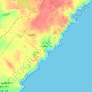
Nom : Carte topographique Collieston, altitude, relief.
Lieu : Collieston, Aberdeenshire, Scotland, AB41 8RT, United Kingdom (57.32959 -1.95555 57.36959 -1.91555)
Altitude moyenne : 23 m
Altitude minimum : 0 m
Altitude maximum : 64 m
Autres cartes topographiques
Cliquez sur une carte pour visualiser sa topographie, son altitude et son relief.
Dunnottar Castle
United Kingdom > Scotland > Aberdeenshire > Stonehaven > Mains of Dunnottar
Altitude moyenne : 33 m
Cairngorm Mountains
United Kingdom > Scotland > Aberdeenshire
In terms of height, remoteness and the severe and changeable weather, the Cairngorms are the most arduous area in the United Kingdom. The plateau area has a Tundra climate (Köppen ET), and the shattered terrain is more like the high ground in high-arctic Canada or northern Norway than what is often observed…
Altitude moyenne : 619 m
Forvie National Nature Reserve
United Kingdom > Scotland > Aberdeenshire > Newburgh
Altitude moyenne : 15 m
Glen Tanar
United Kingdom > Scotland > Aberdeenshire > Aboyne
Glen Tanar, along with the side glens formed by the Water of Gairney and the Water of Allachy, comprises the third largest area of Caledonian Forest in Scotland, which grows from the valley floor up to an altitude of 450 metres. As a Caledonian Forest, the predominant tree species is Scots pine, although…
Altitude moyenne : 389 m