
Carte topographique Brown-Lowery Provincial Park
Carte interactive
Cliquez sur la carte pour afficher l’altitude.
À propos de cette carte
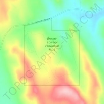
Nom : Carte topographique Brown-Lowery Provincial Park, altitude, relief.
Altitude moyenne : 1 353 m
Altitude minimum : 1 273 m
Altitude maximum : 1 454 m
Autres cartes topographiques
Cliquez sur une carte pour visualiser sa topographie, son altitude et son relief.
Aldersyde
Canada > Alberta > Foothills County
Aldersyde, Foothills County, Alberta, T0L 1T0, Canada
Altitude moyenne : 1 046 m
Sheep River
Canada > Alberta > Foothills County
Sheep River, Foothills County, Alberta, Canada
Altitude moyenne : 1 426 m
Priddis
Canada > Alberta > Foothills County
Priddis, Foothills County, Alberta, Canada
Altitude moyenne : 1 193 m
Millarville
Canada > Alberta > Foothills County
Millarville, Foothills County, Alberta, T0L 1K0, Canada
Altitude moyenne : 1 220 m
Sheep River
Canada > Alberta > Foothills County
Sheep River, Foothills County, Alberta, T0L 2O0, Canada
Altitude moyenne : 1 358 m
Highwood River
Canada > Alberta > Foothills County > Village of Longview
Highwood River, Village of Longview, Foothills County, Alberta, T0L 1H0, Canada
Altitude moyenne : 1 232 m
De Winton
Canada > Alberta > Foothills County
De Winton, Foothills County, Alberta, T2V 3Z4, Canada
Altitude moyenne : 1 104 m
Cayley
Canada > Alberta > Foothills County
Cayley, Foothills County, Alberta, Canada
Altitude moyenne : 1 070 m
Hartell
Canada > Alberta > Foothills County
Hartell, Foothills County, Alberta, Canada
Altitude moyenne : 1 266 m