
Faire un don
Équipez-vous pour votre prochaine aventure :
En tant que Partenaire Amazon, ce site perçoit une commission sur les achats éligibles sans surcoût pour vous.
Carte topographique New Haven County
Cliquez sur la carte pour afficher l’altitude.
Faire un don
Équipez-vous pour votre prochaine aventure :
En tant que Partenaire Amazon, ce site perçoit une commission sur les achats éligibles sans surcoût pour vous.
New Haven County
The terrain is mostly flat near the coast, with low hills defining the rest of the area, rising significantly only in the north of the county. The highest elevation is close to the northernmost point in the county, found at two areas of approximately 1,050 feet (320 m) above sea level in the town of Wolcott. The lowest point is sea level.
Faire un don
Équipez-vous pour votre prochaine aventure :
En tant que Partenaire Amazon, ce site perçoit une commission sur les achats éligibles sans surcoût pour vous.
À propos de cette carte
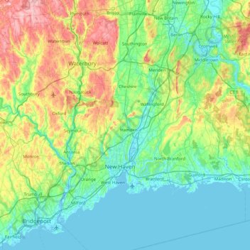
Nom : Carte topographique New Haven County, altitude, relief.
Altitude moyenne : 87 m
Altitude minimum : -4 m
Altitude maximum : 372 m
Faire un don
Équipez-vous pour votre prochaine aventure :
En tant que Partenaire Amazon, ce site perçoit une commission sur les achats éligibles sans surcoût pour vous.
Autres cartes topographiques
Cliquez sur une carte pour visualiser sa topographie, son altitude et son relief.
Sea Bluff
United States > Connecticut > South Central Connecticut Planning Region > West Haven > West Shore
Altitude moyenne : 14 m
Killingworth Court
United States > Connecticut > South Central Connecticut Planning Region > New Haven
Altitude moyenne : 13 m
Hein Trails
United States > Connecticut > South Central Connecticut Planning Region > Bethany > Davidsons Corner
Altitude moyenne : 175 m
Indian Neck
United States > Connecticut > South Central Connecticut Planning Region > Branford
Altitude moyenne : 4 m
Faire un don
Équipez-vous pour votre prochaine aventure :
En tant que Partenaire Amazon, ce site perçoit une commission sur les achats éligibles sans surcoût pour vous.
Northford
United States > Connecticut > South Central Connecticut Planning Region > North Branford
Altitude moyenne : 71 m
Ansonia
United States > Connecticut > South Central Connecticut Planning Region
Altitude moyenne : 111 m
Derby
United States > Connecticut > South Central Connecticut Planning Region
According to the United States Census Bureau, the town has a total area of 5.4 square miles (8.7 km2), of which, 5.0 square miles (13 km2) is land and 0.4 square miles (1.0 km2) (7.41%) is water. The city is home to the 417 acres (0.652 sq mi) Osbornedale State Park. Derby is divided into two main sections by…
Altitude moyenne : 79 m
Momauguin
United States > Connecticut > South Central Connecticut Planning Region > East Haven
Altitude moyenne : 3 m
Faire un don
Équipez-vous pour votre prochaine aventure :
En tant que Partenaire Amazon, ce site perçoit une commission sur les achats éligibles sans surcoût pour vous.
Indian Cave
United States > Connecticut > South Central Connecticut Planning Region > Guilford
Altitude moyenne : 25 m
North Madison
United States > Connecticut > South Central Connecticut Planning Region > Madison
Altitude moyenne : 91 m
Nut Plains
United States > Connecticut > South Central Connecticut Planning Region > Guilford
Altitude moyenne : 35 m
Fort Trumbull
United States > Connecticut > South Central Connecticut Planning Region > Milford
Altitude moyenne : 7 m
Faire un don
Équipez-vous pour votre prochaine aventure :
En tant que Partenaire Amazon, ce site perçoit une commission sur les achats éligibles sans surcoût pour vous.
Branford Court
United States > Connecticut > South Central Connecticut Planning Region > New Haven
Altitude moyenne : 13 m
West Shore
United States > Connecticut > South Central Connecticut Planning Region > West Haven
Altitude moyenne : 9 m
North Haven Bridge
United States > Connecticut > South Central Connecticut Planning Region > North Haven
Altitude moyenne : 22 m
Lake Whitney
United States > Connecticut > South Central Connecticut Planning Region > Hamden > Whitneyville
Altitude moyenne : 25 m
Faire un don
Équipez-vous pour votre prochaine aventure :
En tant que Partenaire Amazon, ce site perçoit une commission sur les achats éligibles sans surcoût pour vous.
Jeffrey Point
United States > Connecticut > South Central Connecticut Planning Region > Branford
Altitude moyenne : 1 m
West Shore
United States > Connecticut > South Central Connecticut Planning Region > West Haven
Altitude moyenne : 9 m
South End Point
United States > Connecticut > South Central Connecticut Planning Region > East Haven > Momauguin
Altitude moyenne : 2 m
Lake Whitney
United States > Connecticut > South Central Connecticut Planning Region > Hamden
Altitude moyenne : 25 m
Faire un don
Équipez-vous pour votre prochaine aventure :
En tant que Partenaire Amazon, ce site perçoit une commission sur les achats éligibles sans surcoût pour vous.
Forest Heights
United States > Connecticut > South Central Connecticut Planning Region > Milford
Altitude moyenne : 19 m
Silver Beach
United States > Connecticut > South Central Connecticut Planning Region > Milford > Fort Trumbull
Altitude moyenne : 5 m
Branford Hills
United States > Connecticut > South Central Connecticut Planning Region > Branford
Altitude moyenne : 12 m
East Peak
United States > Connecticut > South Central Connecticut Planning Region > Meriden
Altitude moyenne : 154 m
Faire un don
Équipez-vous pour votre prochaine aventure :
En tant que Partenaire Amazon, ce site perçoit une commission sur les achats éligibles sans surcoût pour vous.
Momauguin
United States > Connecticut > South Central Connecticut Planning Region > East Haven
Altitude moyenne : 3 m
Silver Beach
United States > Connecticut > South Central Connecticut Planning Region > Milford
Altitude moyenne : 5 m
Nut Plains
United States > Connecticut > South Central Connecticut Planning Region > Guilford
Altitude moyenne : 35 m
South Meriden
United States > Connecticut > South Central Connecticut Planning Region > Meriden
Altitude moyenne : 55 m
Faire un don
Équipez-vous pour votre prochaine aventure :
En tant que Partenaire Amazon, ce site perçoit une commission sur les achats éligibles sans surcoût pour vous.
Bayview
United States > Connecticut > South Central Connecticut Planning Region > Milford
Altitude moyenne : 5 m
Brightview
United States > Connecticut > South Central Connecticut Planning Region > New Haven
Altitude moyenne : 5 m
Fort Trumbull
United States > Connecticut > South Central Connecticut Planning Region > Milford
Altitude moyenne : 7 m
Sea Bluff
United States > Connecticut > South Central Connecticut Planning Region > West Haven > West Shore
Altitude moyenne : 14 m
Faire un don
Équipez-vous pour votre prochaine aventure :
En tant que Partenaire Amazon, ce site perçoit une commission sur les achats éligibles sans surcoût pour vous.
Mount Carmel Center
United States > Connecticut > South Central Connecticut Planning Region > Hamden
Altitude moyenne : 79 m
Morningside
United States > Connecticut > South Central Connecticut Planning Region > Milford
Altitude moyenne : 5 m
East River
United States > Connecticut > South Central Connecticut Planning Region > Madison
Altitude moyenne : 9 m
Big Indian
United States > Connecticut > South Central Connecticut Planning Region > Guilford
Altitude moyenne : 41 m
Faire un don
Équipez-vous pour votre prochaine aventure :
En tant que Partenaire Amazon, ce site perçoit une commission sur les achats éligibles sans surcoût pour vous.
Sunset Hill
United States > Connecticut > South Central Connecticut Planning Region > Branford
Altitude moyenne : 12 m
Sea Bluff
United States > Connecticut > South Central Connecticut Planning Region > West Haven > West Shore
Altitude moyenne : 14 m
Clark Hill
United States > Connecticut > South Central Connecticut Planning Region > Milford
Altitude moyenne : 11 m
Peter's Rock
United States > Connecticut > South Central Connecticut Planning Region > North Haven
Altitude moyenne : 38 m
Faire un don
Équipez-vous pour votre prochaine aventure :
En tant que Partenaire Amazon, ce site perçoit une commission sur les achats éligibles sans surcoût pour vous.
Quinnipiac
United States > Connecticut > South Central Connecticut Planning Region > Wallingford
Altitude moyenne : 31 m
North Branford Town Green
United States > Connecticut > South Central Connecticut Planning Region > North Branford
Altitude moyenne : 44 m
Fair Haven East
United States > Connecticut > South Central Connecticut Planning Region > New Haven
Altitude moyenne : 14 m
Allingtown
United States > Connecticut > South Central Connecticut Planning Region > West Haven
Altitude moyenne : 26 m
Faire un don
Équipez-vous pour votre prochaine aventure :
En tant que Partenaire Amazon, ce site perçoit une commission sur les achats éligibles sans surcoût pour vous.