
Faire un don
Équipez-vous pour votre prochaine aventure :
En tant que Partenaire Amazon, ce site perçoit une commission sur les achats éligibles sans surcoût pour vous.
Carte topographique Ansonia
Cliquez sur la carte pour afficher l’altitude.
Faire un don
Équipez-vous pour votre prochaine aventure :
En tant que Partenaire Amazon, ce site perçoit une commission sur les achats éligibles sans surcoût pour vous.
À propos de cette carte
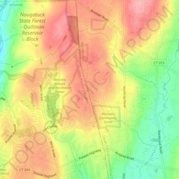
Nom : Carte topographique Ansonia, altitude, relief.
Altitude moyenne : 111 m
Altitude minimum : 43 m
Altitude maximum : 162 m
Faire un don
Équipez-vous pour votre prochaine aventure :
En tant que Partenaire Amazon, ce site perçoit une commission sur les achats éligibles sans surcoût pour vous.
Autres cartes topographiques
Cliquez sur une carte pour visualiser sa topographie, son altitude et son relief.
Guilford
United States > Connecticut > South Central Connecticut Planning Region
Altitude moyenne : 62 m
New Haven
United States > Connecticut > South Central Connecticut Planning Region
Altitude moyenne : 20 m
Hamden
United States > Connecticut > South Central Connecticut Planning Region
Altitude moyenne : 64 m
North Haven
United States > Connecticut > South Central Connecticut Planning Region
Altitude moyenne : 38 m
Faire un don
Équipez-vous pour votre prochaine aventure :
En tant que Partenaire Amazon, ce site perçoit une commission sur les achats éligibles sans surcoût pour vous.
Sea Bluff
United States > Connecticut > South Central Connecticut Planning Region > West Haven > West Shore
Altitude moyenne : 14 m
Meriden
United States > Connecticut > South Central Connecticut Planning Region
Altitude moyenne : 88 m
New Haven County
United States > Connecticut > South Central Connecticut Planning Region
The terrain is mostly flat near the coast, with low hills defining the rest of the area, rising significantly only in the north of the county. The highest elevation is close to the northernmost point in the county, found at two areas of approximately 1,050 feet (320 m) above sea level in the town of Wolcott.…
Altitude moyenne : 87 m
Bethany
United States > Connecticut > South Central Connecticut Planning Region
Altitude moyenne : 162 m
Faire un don
Équipez-vous pour votre prochaine aventure :
En tant que Partenaire Amazon, ce site perçoit une commission sur les achats éligibles sans surcoût pour vous.
Indian Neck
United States > Connecticut > South Central Connecticut Planning Region > Branford
Altitude moyenne : 4 m
Madison
United States > Connecticut > South Central Connecticut Planning Region
Altitude moyenne : 69 m
Woodbridge
United States > Connecticut > South Central Connecticut Planning Region
Altitude moyenne : 96 m
Northford
United States > Connecticut > South Central Connecticut Planning Region > North Branford
Altitude moyenne : 71 m
Faire un don
Équipez-vous pour votre prochaine aventure :
En tant que Partenaire Amazon, ce site perçoit une commission sur les achats éligibles sans surcoût pour vous.
Wallingford
United States > Connecticut > South Central Connecticut Planning Region
Altitude moyenne : 72 m
Milford
United States > Connecticut > South Central Connecticut Planning Region
Altitude moyenne : 18 m
North Branford
United States > Connecticut > South Central Connecticut Planning Region
Altitude moyenne : 68 m
Orange
United States > Connecticut > South Central Connecticut Planning Region
Altitude moyenne : 47 m
Faire un don
Équipez-vous pour votre prochaine aventure :
En tant que Partenaire Amazon, ce site perçoit une commission sur les achats éligibles sans surcoût pour vous.
West Haven
United States > Connecticut > South Central Connecticut Planning Region
Altitude moyenne : 16 m
Borough of Woodmont
United States > Connecticut > South Central Connecticut Planning Region > Milford
A majority of the borough land mass is safely above sea level. However, it does have a few low elevation areas which are subject to flooding during very heavy storm situations (Hurricanes). The most recent, circa 2013 FEMA generated flood map is shown at the right, with the borough border roughly outlined in…
Altitude moyenne : 3 m
Momauguin
United States > Connecticut > South Central Connecticut Planning Region > East Haven
Altitude moyenne : 3 m
Indian Cave
United States > Connecticut > South Central Connecticut Planning Region > Guilford
Altitude moyenne : 25 m
Faire un don
Équipez-vous pour votre prochaine aventure :
En tant que Partenaire Amazon, ce site perçoit une commission sur les achats éligibles sans surcoût pour vous.
North Madison
United States > Connecticut > South Central Connecticut Planning Region > Madison
Altitude moyenne : 91 m
Nut Plains
United States > Connecticut > South Central Connecticut Planning Region > Guilford
Altitude moyenne : 35 m
Fort Trumbull
United States > Connecticut > South Central Connecticut Planning Region > Milford
Altitude moyenne : 7 m
Guilford
United States > Connecticut > South Central Connecticut Planning Region
Altitude moyenne : 62 m
Faire un don
Équipez-vous pour votre prochaine aventure :
En tant que Partenaire Amazon, ce site perçoit une commission sur les achats éligibles sans surcoût pour vous.
Branford
United States > Connecticut > South Central Connecticut Planning Region
Altitude moyenne : 17 m
West Shore
United States > Connecticut > South Central Connecticut Planning Region > West Haven
Altitude moyenne : 9 m
North Haven Bridge
United States > Connecticut > South Central Connecticut Planning Region > North Haven
Altitude moyenne : 22 m
Jeffrey Point
United States > Connecticut > South Central Connecticut Planning Region > Branford
Altitude moyenne : 1 m
Faire un don
Équipez-vous pour votre prochaine aventure :
En tant que Partenaire Amazon, ce site perçoit une commission sur les achats éligibles sans surcoût pour vous.
Meriden
United States > Connecticut > South Central Connecticut Planning Region
Altitude moyenne : 88 m
West Shore
United States > Connecticut > South Central Connecticut Planning Region > West Haven
Altitude moyenne : 9 m
Hamden
United States > Connecticut > South Central Connecticut Planning Region
Altitude moyenne : 64 m
Sleeping Giant State Park
United States > Connecticut > South Central Connecticut Planning Region > Hamden
Sleeping Giant (also known as the Blue Hills and Mount Carmel), (Hobbomock in Quinnipiac), is a rugged traprock mountain with a high point of 739 feet (225 m), located eight miles (13 km) north of New Haven, Connecticut. A prominent landscape feature visible for miles, the Sleeping Giant receives its name from…
Altitude moyenne : 79 m
Faire un don
Équipez-vous pour votre prochaine aventure :
En tant que Partenaire Amazon, ce site perçoit une commission sur les achats éligibles sans surcoût pour vous.
South End Point
United States > Connecticut > South Central Connecticut Planning Region > East Haven > Momauguin
Altitude moyenne : 2 m
West Haven
United States > Connecticut > South Central Connecticut Planning Region
Altitude moyenne : 16 m
Forest Heights
United States > Connecticut > South Central Connecticut Planning Region > Milford
Altitude moyenne : 19 m
New Haven
United States > Connecticut > South Central Connecticut Planning Region
Altitude moyenne : 20 m
Faire un don
Équipez-vous pour votre prochaine aventure :
En tant que Partenaire Amazon, ce site perçoit une commission sur les achats éligibles sans surcoût pour vous.
Silver Beach
United States > Connecticut > South Central Connecticut Planning Region > Milford > Fort Trumbull
Altitude moyenne : 5 m
Branford Hills
United States > Connecticut > South Central Connecticut Planning Region > Branford
Altitude moyenne : 12 m
North Haven
United States > Connecticut > South Central Connecticut Planning Region
Altitude moyenne : 38 m
East Peak
United States > Connecticut > South Central Connecticut Planning Region > Meriden
Altitude moyenne : 154 m
Faire un don
Équipez-vous pour votre prochaine aventure :
En tant que Partenaire Amazon, ce site perçoit une commission sur les achats éligibles sans surcoût pour vous.
New Haven
United States > Connecticut > South Central Connecticut Planning Region
Altitude moyenne : 20 m
New Haven County
United States > Connecticut > South Central Connecticut Planning Region
The terrain is mostly flat near the coast, with low hills defining the rest of the area, rising significantly only in the north of the county. The highest elevation is close to the northernmost point in the county, found at two areas of approximately 1,050 feet (320 m) above sea level in the town of Wolcott.…
Altitude moyenne : 87 m
New Haven
United States > Connecticut > South Central Connecticut Planning Region
Altitude moyenne : 20 m
West Haven
United States > Connecticut > South Central Connecticut Planning Region
Altitude moyenne : 16 m
Faire un don
Équipez-vous pour votre prochaine aventure :
En tant que Partenaire Amazon, ce site perçoit une commission sur les achats éligibles sans surcoût pour vous.
Momauguin
United States > Connecticut > South Central Connecticut Planning Region > East Haven
Altitude moyenne : 3 m
Silver Beach
United States > Connecticut > South Central Connecticut Planning Region > Milford
Altitude moyenne : 5 m
Nut Plains
United States > Connecticut > South Central Connecticut Planning Region > Guilford
Altitude moyenne : 35 m
Woodbridge
United States > Connecticut > South Central Connecticut Planning Region
Altitude moyenne : 96 m
Faire un don
Équipez-vous pour votre prochaine aventure :
En tant que Partenaire Amazon, ce site perçoit une commission sur les achats éligibles sans surcoût pour vous.
Milford
United States > Connecticut > South Central Connecticut Planning Region
Altitude moyenne : 18 m
Wallingford
United States > Connecticut > South Central Connecticut Planning Region
Altitude moyenne : 72 m
South Meriden
United States > Connecticut > South Central Connecticut Planning Region > Meriden
Altitude moyenne : 55 m
Bayview
United States > Connecticut > South Central Connecticut Planning Region > Milford
Altitude moyenne : 5 m
Faire un don
Équipez-vous pour votre prochaine aventure :
En tant que Partenaire Amazon, ce site perçoit une commission sur les achats éligibles sans surcoût pour vous.
Bethany
United States > Connecticut > South Central Connecticut Planning Region
Altitude moyenne : 162 m
Brightview
United States > Connecticut > South Central Connecticut Planning Region > New Haven
Altitude moyenne : 5 m
Fort Trumbull
United States > Connecticut > South Central Connecticut Planning Region > Milford
Altitude moyenne : 7 m
Orange
United States > Connecticut > South Central Connecticut Planning Region
Altitude moyenne : 47 m
Faire un don
Équipez-vous pour votre prochaine aventure :
En tant que Partenaire Amazon, ce site perçoit une commission sur les achats éligibles sans surcoût pour vous.
Sea Bluff
United States > Connecticut > South Central Connecticut Planning Region > West Haven > West Shore
Altitude moyenne : 14 m
Mount Carmel Center
United States > Connecticut > South Central Connecticut Planning Region > Hamden
Altitude moyenne : 79 m
Morningside
United States > Connecticut > South Central Connecticut Planning Region > Milford
Altitude moyenne : 5 m
Milford
United States > Connecticut > South Central Connecticut Planning Region
Altitude moyenne : 18 m
Faire un don
Équipez-vous pour votre prochaine aventure :
En tant que Partenaire Amazon, ce site perçoit une commission sur les achats éligibles sans surcoût pour vous.
East River
United States > Connecticut > South Central Connecticut Planning Region > Madison
Altitude moyenne : 9 m
Big Indian
United States > Connecticut > South Central Connecticut Planning Region > Guilford
Altitude moyenne : 41 m
Sunset Hill
United States > Connecticut > South Central Connecticut Planning Region > Branford
Altitude moyenne : 12 m
Sea Bluff
United States > Connecticut > South Central Connecticut Planning Region > West Haven > West Shore
Altitude moyenne : 14 m
Faire un don
Équipez-vous pour votre prochaine aventure :
En tant que Partenaire Amazon, ce site perçoit une commission sur les achats éligibles sans surcoût pour vous.
Clark Hill
United States > Connecticut > South Central Connecticut Planning Region > Milford
Altitude moyenne : 11 m
Peter's Rock
United States > Connecticut > South Central Connecticut Planning Region > North Haven
Altitude moyenne : 38 m
West Haven
United States > Connecticut > South Central Connecticut Planning Region
Altitude moyenne : 16 m
Milford
United States > Connecticut > South Central Connecticut Planning Region
Altitude moyenne : 18 m
Faire un don
Équipez-vous pour votre prochaine aventure :
En tant que Partenaire Amazon, ce site perçoit une commission sur les achats éligibles sans surcoût pour vous.
Quinnipiac
United States > Connecticut > South Central Connecticut Planning Region > Wallingford
Altitude moyenne : 31 m
Branford
United States > Connecticut > South Central Connecticut Planning Region
Altitude moyenne : 17 m
Fair Haven East
United States > Connecticut > South Central Connecticut Planning Region > New Haven
Altitude moyenne : 14 m
New Haven
United States > Connecticut > South Central Connecticut Planning Region
Altitude moyenne : 20 m
Faire un don
Équipez-vous pour votre prochaine aventure :
En tant que Partenaire Amazon, ce site perçoit une commission sur les achats éligibles sans surcoût pour vous.
North Branford
United States > Connecticut > South Central Connecticut Planning Region
Altitude moyenne : 68 m
New Haven
United States > Connecticut > South Central Connecticut Planning Region
Altitude moyenne : 20 m
Allingtown
United States > Connecticut > South Central Connecticut Planning Region > West Haven
Altitude moyenne : 26 m
Meriden
United States > Connecticut > South Central Connecticut Planning Region
Altitude moyenne : 92 m
Faire un don
Équipez-vous pour votre prochaine aventure :
En tant que Partenaire Amazon, ce site perçoit une commission sur les achats éligibles sans surcoût pour vous.
Milford
United States > Connecticut > South Central Connecticut Planning Region
Altitude moyenne : 18 m
Milford
United States > Connecticut > South Central Connecticut Planning Region
Altitude moyenne : 18 m