
Carte topographique Iron Bridge
Cliquez sur la carte pour afficher l’altitude.
À propos de cette carte
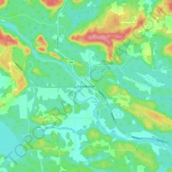
Nom : Carte topographique Iron Bridge, altitude, relief.
Altitude moyenne : 200 m
Altitude minimum : 172 m
Altitude maximum : 270 m
Autres cartes topographiques
Cliquez sur une carte pour visualiser sa topographie, son altitude et son relief.
Lucille Lake;Wood Creek
Canada > Ontario > Algoma District > Unorganized North Algoma
Altitude moyenne : 441 m
St. Joseph Island
Canada > Ontario > Algoma District > Jocelyn Township
Its highest point, known colloquially and by surveyors as "the Mountain", is near the centre of the island near Carterton with an elevation of 345.6 m, which is about 169 m above Lake Huron.
Altitude moyenne : 196 m
Kabinakagami Lake
Canada > Ontario > Algoma District > Unorganized North Algoma
Altitude moyenne : 332 m
Kirkpatrick Lake
Canada > Ontario > Algoma District > Unorganized North Algoma
Altitude moyenne : 429 m
Kimiwan Creek;Kimiwan Lakes
Canada > Ontario > Algoma District > Unorganized North Algoma
Altitude moyenne : 442 m
Lauzon Lake
Canada > Ontario > Algoma District > The North Shore Township > Algoma Mills
Altitude moyenne : 210 m
Montreal Island
Canada > Ontario > Algoma District > Unorganized North Algoma
Altitude moyenne : 190 m
Kabinakagamisis Lake
Canada > Ontario > Algoma District > Unorganized North Algoma
Altitude moyenne : 324 m
St. Joseph Island
Canada > Ontario > Algoma District > Jocelyn Township
Its highest point, known colloquially and by surveyors as "the Mountain", is near the centre of the island near Carterton with an elevation of 345.6 m, which is about 169 m above Lake Huron.
Altitude moyenne : 196 m