
Faire un don
Équipez-vous pour votre prochaine aventure :
En tant que Partenaire Amazon, ce site perçoit une commission sur les achats éligibles sans surcoût pour vous.
Carte topographique Dunbar
Cliquez sur la carte pour afficher l’altitude.
Faire un don
Équipez-vous pour votre prochaine aventure :
En tant que Partenaire Amazon, ce site perçoit une commission sur les achats éligibles sans surcoût pour vous.
À propos de cette carte
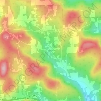
Nom : Carte topographique Dunbar, altitude, relief.
Altitude moyenne : 484 m
Altitude minimum : 370 m
Altitude maximum : 591 m
Faire un don
Équipez-vous pour votre prochaine aventure :
En tant que Partenaire Amazon, ce site perçoit une commission sur les achats éligibles sans surcoût pour vous.
Autres cartes topographiques
Cliquez sur une carte pour visualiser sa topographie, son altitude et son relief.
City of Binghamton
United States > New York > Broome County
Binghamton, like all of the Southern Tier of New York, lies on the Allegheny Plateau; hence its hilly terrain. As such, elevations can vary in the city--Downtown, for example, is at an elevation of around 860 feet, while residential homes in the hills can go up to over 1,800 feet, such as on Ingram Hill. The…
Altitude moyenne : 321 m
Chenango Bridge
United States > New York > Broome County > Chenango Bridge
Chenango Bridge is located at 42°10′00″N 075°51′45″W / 42.16667°N 75.86250°W / 42.16667; -75.86250 (42.1667426, -75.8624167) and its elevation is 896 feet (273 m).
Altitude moyenne : 310 m
Faire un don
Équipez-vous pour votre prochaine aventure :
En tant que Partenaire Amazon, ce site perçoit une commission sur les achats éligibles sans surcoût pour vous.
Glen Aubrey
United States > New York > Broome County > Town of Nanticoke > Glen Aubrey
Altitude moyenne : 372 m
Faire un don
Équipez-vous pour votre prochaine aventure :
En tant que Partenaire Amazon, ce site perçoit une commission sur les achats éligibles sans surcoût pour vous.
Oquaga Creek State Park
United States > New York > Broome County > Town of Sanford
Altitude moyenne : 533 m
Faire un don
Équipez-vous pour votre prochaine aventure :
En tant que Partenaire Amazon, ce site perçoit une commission sur les achats éligibles sans surcoût pour vous.
City of Binghamton
United States > New York > Broome County
Binghamton, like all of the Southern Tier of New York, lies on the Allegheny Plateau; hence its hilly terrain. As such, elevations can vary in the city--Downtown, for example, is at an elevation of around 860 feet, while residential homes in the hills can go up to over 1,800 feet, such as on Ingram Hill. The…
Altitude moyenne : 321 m
City of Binghamton
United States > New York > Broome County
Binghamton, like all of the Southern Tier of New York, lies on the Allegheny Plateau; hence its hilly terrain. As such, elevations can vary in the city--Downtown, for example, is at an elevation of around 860 feet (262 meters), while residential homes in the hills can go up to over 1,800 feet (548 meters),…
Altitude moyenne : 321 m
Faire un don
Équipez-vous pour votre prochaine aventure :
En tant que Partenaire Amazon, ce site perçoit une commission sur les achats éligibles sans surcoût pour vous.
Faire un don
Équipez-vous pour votre prochaine aventure :
En tant que Partenaire Amazon, ce site perçoit une commission sur les achats éligibles sans surcoût pour vous.
Faire un don
Équipez-vous pour votre prochaine aventure :
En tant que Partenaire Amazon, ce site perçoit une commission sur les achats éligibles sans surcoût pour vous.
Faire un don
Équipez-vous pour votre prochaine aventure :
En tant que Partenaire Amazon, ce site perçoit une commission sur les achats éligibles sans surcoût pour vous.