
Faire un don
Équipez-vous pour votre prochaine aventure :
En tant que Partenaire Amazon, ce site perçoit une commission sur les achats éligibles sans surcoût pour vous.
Carte topographique New York
Cliquez sur la carte pour afficher l’altitude.
Faire un don
Équipez-vous pour votre prochaine aventure :
En tant que Partenaire Amazon, ce site perçoit une commission sur les achats éligibles sans surcoût pour vous.
New York
The city's land has been altered substantially by human intervention, with considerable land reclamation along the waterfronts since Dutch colonial times; reclamation is most prominent in Lower Manhattan, with developments such as Battery Park City in the 1970s and 1980s. Some of the natural relief in topography has been evened out, especially in Manhattan.
Faire un don
Équipez-vous pour votre prochaine aventure :
En tant que Partenaire Amazon, ce site perçoit une commission sur les achats éligibles sans surcoût pour vous.
À propos de cette carte
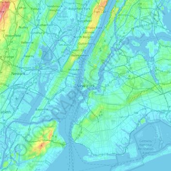
Nom : Carte topographique New York, altitude, relief.
Lieu : New York, New York County, New York, 10000, United States (40.55273 -74.16602 40.87273 -73.84602)
Altitude moyenne : 15 m
Altitude minimum : -10 m
Altitude maximum : 186 m
Faire un don
Équipez-vous pour votre prochaine aventure :
En tant que Partenaire Amazon, ce site perçoit une commission sur les achats éligibles sans surcoût pour vous.
Autres cartes topographiques
Cliquez sur une carte pour visualiser sa topographie, son altitude et son relief.
Highbridge Park
United States > New York > New York County > New York
The north and south wings respectively contain the women's and men's locker rooms and are nearly identical. Both have nine windows separated by eight brick pilasters. The stone capitals of the pilasters line up with the lintels of the windows. Ramps lead from the extreme ends of each wing. The ground slopes…
Altitude moyenne : 30 m
Fort Tryon Park
United States > New York > New York County > New York
In preparation for converting the land into a city park, Rockefeller hired the Olmsted Brothers firm, particularly Frederick Law Olmsted Jr., son of the designer of Central Park. Olmsted's design capitalized on the topography to reveal sweeping vistas of the Hudson River and the Palisades. Olmsted Jr. was…
Altitude moyenne : 20 m
Faire un don
Équipez-vous pour votre prochaine aventure :
En tant que Partenaire Amazon, ce site perçoit une commission sur les achats éligibles sans surcoût pour vous.
Morningside Park
United States > New York > New York County > New York
Dutch settlers occupied Manhattan in the early 17th century and called the area around Morningside Park Vredendal, meaning 'peaceful dale'. The lowlands to the east were called Flacken by the Dutch, and were later translated to "Flats" in English. The land to the east was not settled initially because of its…
Altitude moyenne : 20 m
Faire un don
Équipez-vous pour votre prochaine aventure :
En tant que Partenaire Amazon, ce site perçoit une commission sur les achats éligibles sans surcoût pour vous.
Faire un don
Équipez-vous pour votre prochaine aventure :
En tant que Partenaire Amazon, ce site perçoit une commission sur les achats éligibles sans surcoût pour vous.
Hunter’s Point South Waterfront Park
United States > New York > New York County > New York
Altitude moyenne : 5 m