
Carte topographique Gogar
Cliquez sur la carte pour afficher l’altitude.
À propos de cette carte
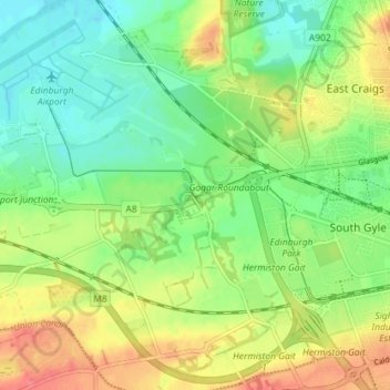
Nom : Carte topographique Gogar, altitude, relief.
Lieu : Gogar, City of Edinburgh, Scotland, EH12 9BR, United Kingdom (55.91802 -3.35328 55.95802 -3.31328)
Altitude moyenne : 51 m
Altitude minimum : 25 m
Altitude maximum : 87 m
Autres cartes topographiques
Cliquez sur une carte pour visualiser sa topographie, son altitude et son relief.
Currie
United Kingdom > Scotland > City of Edinburgh
The period 1921-1951 brought great changes with the building of more council houses in Currie and private building along Lanark Road. Wider scale development began in the late 1950s and early 1960s with the construction of a private housing estate to the east of Curriehill Road. House builders began to promote…
Altitude moyenne : 163 m
Hermitage of Braid and Blackford Hill Local Nature Reserve
United Kingdom > Scotland > City of Edinburgh
Altitude moyenne : 107 m
St Mark's Park Community Woodland
United Kingdom > Scotland > City of Edinburgh
Altitude moyenne : 23 m