Géolocaliser

Carte topographique Longstone

Cliquez sur la carte pour afficher l’altitude.

À propos de cette carte

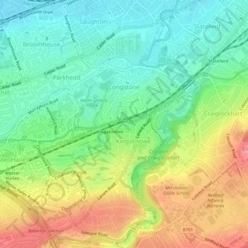
Nom : Carte topographique Longstone, altitude, relief.

Lieu : Longstone, City of Edinburgh, Scotland, United Kingdom (55.91177 -3.27274 55.92643 -3.24796)

Altitude moyenne : 85 m

Altitude minimum : 47 m

Altitude maximum : 141 m

👉 Easily get elevation data in JSON, GeoTIFF and KML formats using Elevation API
Merci de soutenir ce site ❤️
Faire un don

Équipez-vous pour votre prochaine aventure :

En tant que Partenaire Amazon, ce site perçoit une commission sur les achats éligibles sans surcoût pour vous.

Autres cartes topographiques

Cliquez sur une carte pour visualiser sa topographie, son altitude et son relief.

Ratho

United Kingdom > Scotland > City of Edinburgh

Altitude moyenne : 80 m

Hillend

United Kingdom > Scotland > City of Edinburgh > Ratho

Altitude moyenne : 67 m

Gogar

United Kingdom > Scotland > City of Edinburgh

Altitude moyenne : 51 m

Newbridge

United Kingdom > Scotland > City of Edinburgh

Altitude moyenne : 54 m

Crow Hill

United Kingdom > Scotland > City of Edinburgh

Altitude moyenne : 68 m

Hays Park

United Kingdom > Scotland > City of Edinburgh

Altitude moyenne : 45 m

Hillend

United Kingdom > Scotland > City of Edinburgh > Ratho

Altitude moyenne : 67 m

Gogarbank

United Kingdom > Scotland > City of Edinburgh

Altitude moyenne : 69 m

Équipez-vous pour votre prochaine aventure :

🪑Siège de Randonnée - Chaises ultra-compactes pour vos pauses face au panorama.
🐕Harnais Chien Outdoor - Emmenez votre compagnon sur les sentiers luxembourgeois.
🧦Chaussettes de randonnée - Chaussettes techniques anti-ampoules
🔦Lampe Frontale - Éclairage puissant pour vos marches nocturnes ou le camping.
🧴Lubrifiant Chaîne - Entretien de votre transmission pour les longs parcours.

En tant que Partenaire Amazon, ce site perçoit une commission sur les achats éligibles sans surcoût pour vous.