
Faire un don
Équipez-vous pour votre prochaine aventure :
En tant que Partenaire Amazon, ce site perçoit une commission sur les achats éligibles sans surcoût pour vous.
Carte topographique Montefrío
Cliquez sur la carte pour afficher l’altitude.
Faire un don
Équipez-vous pour votre prochaine aventure :
En tant que Partenaire Amazon, ce site perçoit une commission sur les achats éligibles sans surcoût pour vous.
Montefrío
Montefrío is in the northwest of the province of Granada, situated in the region of Loja. The township occupies about 254 km2 and has a density of 25.37 inhabitants / km ². Its geographical coordinates are 37 ° 19 'N, 04 ° 01' W. It is situated at an altitude of 834 m and 57 km from the capital of Granada. Montefrio is limited on the north with the municipalities of Priego de Córdoba and Almedinilla (Córdoba) and Alcalá la Real (Jaén); the southeast with íllora, on the south by Villanueva Mesia and Stump; and on the southwest by Loja and Algarinejo, the latter belonging to the province of Granada.
Faire un don
Équipez-vous pour votre prochaine aventure :
En tant que Partenaire Amazon, ce site perçoit une commission sur les achats éligibles sans surcoût pour vous.
À propos de cette carte
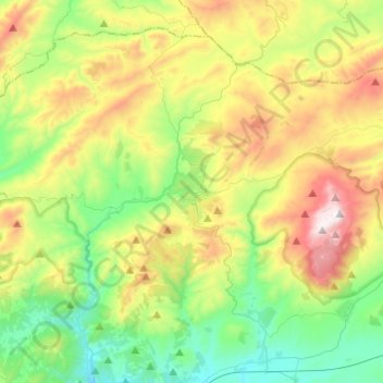
Nom : Carte topographique Montefrío, altitude, relief.
Lieu : Montefrío, Comarca de Loja, Granada, Andalusia, 18270, Spain (37.24157 -4.16231 37.40628 -3.91943)
Altitude moyenne : 895 m
Altitude minimum : 514 m
Altitude maximum : 1 590 m
Faire un don
Équipez-vous pour votre prochaine aventure :
En tant que Partenaire Amazon, ce site perçoit une commission sur les achats éligibles sans surcoût pour vous.
Autres cartes topographiques
Cliquez sur une carte pour visualiser sa topographie, son altitude et son relief.