
Carte topographique Plentzia
Carte interactive
Cliquez sur la carte pour afficher l’altitude.
À propos de cette carte
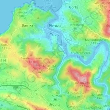
Nom : Carte topographique Plentzia, altitude, relief.
Altitude moyenne : 61 m
Altitude minimum : -5 m
Altitude maximum : 200 m
Autres cartes topographiques
Cliquez sur une carte pour visualiser sa topographie, son altitude et son relief.
Getxo
Spain > Autonomous Community of the Basque Country > Andraka
Getxo, Andraka, Biscay, Autonomous Community of the Basque Country, 48620, Spain
Altitude moyenne : 36 m
Mungia
Spain > Autonomous Community of the Basque Country > Andraka
Mungia, Andraka, Biscay, Autonomous Community of the Basque Country, 48620, Spain
Altitude moyenne : 111 m
Loiu
Spain > Autonomous Community of the Basque Country > Andraka
Loiu, Andraka, Biscay, Autonomous Community of the Basque Country, 48620, Spain
Altitude moyenne : 70 m
Urduliz
Spain > Autonomous Community of the Basque Country > Andraka
Urduliz, Andraka, Biscay, Autonomous Community of the Basque Country, 48620, Spain
Altitude moyenne : 90 m