
Carte topographique Manchester
Carte interactive
Cliquez sur la carte pour afficher l’altitude.
À propos de cette carte
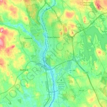
Nom : Carte topographique Manchester, altitude, relief.
Altitude moyenne : 96 m
Altitude minimum : 32 m
Altitude maximum : 245 m
According to the United States Census Bureau, the city has a total area of 35.0 square miles (90.6 km2), of which 33.1 square miles (85.7 km2) are land and 1.9 square miles (4.8 km2) are water, comprising 5.33% of the city. Manchester is drained by the Merrimack River and its tributaries the Piscataquog River and Cohas Brook. Massabesic Lake is on the eastern border. The highest point in Manchester is atop Wellington Hill, where the elevation reaches 570 feet (170 m) above sea level.
Autres cartes topographiques
Cliquez sur une carte pour visualiser sa topographie, son altitude et son relief.
Brookline
United States > New Hampshire > Hillsborough County
Brookline, Hillsborough County, New Hampshire, 03033, United States
Altitude moyenne : 126 m
Milford
United States > New Hampshire > Hillsborough County
Milford, Hillsborough County, New Hampshire, 03055, United States
Altitude moyenne : 114 m
Peterborough
United States > New Hampshire > Hillsborough County
Peterborough, Hillsborough County, New Hampshire, United States
Altitude moyenne : 304 m
Bennington
United States > New Hampshire > Hillsborough County
Bennington, Hillsborough County, New Hampshire, 03442, United States
Altitude moyenne : 260 m
Hillsboro Lower Village
United States > New Hampshire > Hillsborough County > Hillsborough
Hillsboro Lower Village, Hillsborough, Hillsborough County, New Hampshire, 03244, United States
Altitude moyenne : 242 m
Campbell Mountain
United States > New Hampshire > Hillsborough County > Hillsborough
Campbell Mountain, Hillsborough, Hillsborough County, New Hampshire, United States
Altitude moyenne : 338 m
Hollis
United States > New Hampshire > Hillsborough County
Hollis, Hillsborough County, New Hampshire, United States
Altitude moyenne : 101 m
Temple
United States > New Hampshire > Hillsborough County
Temple, Hillsborough County, New Hampshire, 03084, United States
Altitude moyenne : 346 m
Massachusetts Drive Park
United States > New Hampshire > Hillsborough County > Nashua
Massachusetts Drive Park, Ward 7, Nashua, Hillsborough County, New Hampshire, United States
Altitude moyenne : 48 m
Greenfield
United States > New Hampshire > Hillsborough County > Greenfield
Greenfield, Hillsborough County, New Hampshire, 03047, United States
Altitude moyenne : 288 m
Wilton
United States > New Hampshire > Hillsborough County
Wilton, Hillsborough County, New Hampshire, 03086, United States
Altitude moyenne : 179 m
Nashua
United States > New Hampshire > Hillsborough County > Nashua
Nashua, Hillsborough County, New Hampshire, 03060-03064, United States
Altitude moyenne : 82 m
North Brookline
United States > New Hampshire > Hillsborough County > Brookline > North Brookline
North Brookline, Brookline, Hillsborough County, New Hampshire, 03033, United States
Altitude moyenne : 124 m
Nashua
United States > New Hampshire > Hillsborough County
Nashua, Hillsborough County, New Hampshire, United States
Altitude moyenne : 62 m
South Weare
United States > New Hampshire > Hillsborough County > Weare > South Weare
South Weare, Weare, Hillsborough County, New Hampshire, 03281, United States
Altitude moyenne : 210 m
Weare
United States > New Hampshire > Hillsborough County
Weare, Hillsborough County, New Hampshire, United States
Altitude moyenne : 210 m
Hudson
United States > New Hampshire > Hillsborough County
Hudson, Hillsborough County, New Hampshire, 03051, United States
Altitude moyenne : 68 m
Nakuru Lake
United States > New Hampshire > Hillsborough County > Hudson > Hudson Center
Nakuru Lake, Hudson Center, Hudson, Hillsborough County, New Hampshire, United States
Altitude moyenne : 80 m
New Boston
United States > New Hampshire > Hillsborough County
New Boston, Hillsborough County, New Hampshire, 03070, United States
Altitude moyenne : 193 m
Hillsborough
United States > New Hampshire > Hillsborough County
Hillsborough, Hillsborough County, New Hampshire, 03244, United States
Altitude moyenne : 298 m
Pelham
United States > New Hampshire > Hillsborough County
Pelham, Hillsborough County, New Hampshire, 03076, United States
Altitude moyenne : 69 m
Amherst
United States > New Hampshire > Hillsborough County > Amherst
Amherst, Hillsborough County, New Hampshire, 03031, United States
Altitude moyenne : 127 m
Merrimack
United States > New Hampshire > Hillsborough County > Merrimack
Merrimack, Hillsborough County, New Hampshire, 03054, United States
Altitude moyenne : 68 m
Goffstown
United States > New Hampshire > Hillsborough County
Goffstown, Hillsborough County, New Hampshire, 03045, United States
Altitude moyenne : 159 m
Bedford
United States > New Hampshire > Hillsborough County
Bedford, Hillsborough County, New Hampshire, 03110, United States
Altitude moyenne : 97 m