
Faire un don
Équipez-vous pour votre prochaine aventure :
En tant que Partenaire Amazon, ce site perçoit une commission sur les achats éligibles sans surcoût pour vous.
Carte topographique Birken
Cliquez sur la carte pour afficher l’altitude.
Faire un don
Équipez-vous pour votre prochaine aventure :
En tant que Partenaire Amazon, ce site perçoit une commission sur les achats éligibles sans surcoût pour vous.
À propos de cette carte
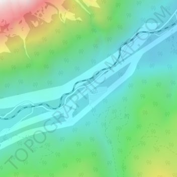
Nom : Carte topographique Birken, altitude, relief.
Altitude moyenne : 796 m
Altitude minimum : 386 m
Altitude maximum : 2 213 m
Faire un don
Équipez-vous pour votre prochaine aventure :
En tant que Partenaire Amazon, ce site perçoit une commission sur les achats éligibles sans surcoût pour vous.
Autres cartes topographiques
Cliquez sur une carte pour visualiser sa topographie, son altitude et son relief.
Lillooet Lake
Canada > British Columbia > Squamish-Lillooet Regional District > Area C (Pemberton Valley/Mount Currie/D'Arcy)
Altitude moyenne : 1 177 m
Joffre Lakes Provincial Park
Canada > British Columbia > Squamish-Lillooet Regional District > Area C (Pemberton Valley/Mount Currie/D'Arcy)
Staying on the trail is important for the preservation of the park environment, and for the safety of hikers. Lower Joffre Lake is a short distance away from the parking lot with no elevation gain. The trail to Middle and Upper Joffre lakes however is more challenging due to the greater elevation gain. Hiking…
Altitude moyenne : 1 911 m
Birkenhead Lake Provincial Park
Canada > British Columbia > Squamish-Lillooet Regional District > Area C (Pemberton Valley/Mount Currie/D'Arcy)
Altitude moyenne : 1 558 m
Lillooet Glacier
Canada > British Columbia > Squamish-Lillooet Regional District > Area C (Pemberton Valley/Mount Currie/D'Arcy)
Altitude moyenne : 2 171 m
Faire un don
Équipez-vous pour votre prochaine aventure :
En tant que Partenaire Amazon, ce site perçoit une commission sur les achats éligibles sans surcoût pour vous.
Bishop Glacier
Canada > British Columbia > Squamish-Lillooet Regional District > Area C (Pemberton Valley/Mount Currie/D'Arcy)
Altitude moyenne : 1 932 m
Overlord Glacier
Canada > British Columbia > Squamish-Lillooet Regional District > Area C (Pemberton Valley/Mount Currie/D'Arcy)
Altitude moyenne : 2 133 m
Joffre Lakes Provincial Park
Canada > British Columbia > Squamish-Lillooet Regional District > Area C (Pemberton Valley/Mount Currie/D'Arcy)
Staying on the trail is important for the preservation of the park environment, and for the safety of hikers. Lower Joffre Lake is a short distance away from the parking lot with no elevation gain. The trail to Middle and Upper Joffre lakes however is more challenging due to the greater elevation gain. Hiking…
Altitude moyenne : 1 911 m
Needles Glacier
Canada > British Columbia > Squamish-Lillooet Regional District > Area C (Pemberton Valley/Mount Currie/D'Arcy)
Altitude moyenne : 2 126 m
Faire un don
Équipez-vous pour votre prochaine aventure :
En tant que Partenaire Amazon, ce site perçoit une commission sur les achats éligibles sans surcoût pour vous.