
Carte topographique Northill
Cliquez sur la carte pour afficher l’altitude.
Northill
Topographically, Northill stands on a slightly elevated ridge that runs north to south. The village lies on the border of the Bedfordshire and Cambridgeshire Claylands and the Bedfordshire Greensand Ridge; National Character Areas designated by Natural England. Central Bedfordshire Council has classified the local landscape around the village as within the Mid Greensand Ridge. The surrounding area is mostly arable farmland but there are significant areas of woodland to the west of the village, and parkland at Ickwell. The north and east of the parish form part of the predominantly flat, Lower Ivel Clay Valley.
À propos de cette carte
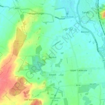
Nom : Carte topographique Northill, altitude, relief.
Lieu : Northill, Central Bedfordshire, England, United Kingdom (52.08943 -0.35975 52.12687 -0.26882)
Altitude moyenne : 37 m
Altitude minimum : 19 m
Altitude maximum : 80 m
Autres cartes topographiques
Cliquez sur une carte pour visualiser sa topographie, son altitude et son relief.
Lower Caldecote
United Kingdom > England > Central Bedfordshire > Upper Caldecote
Altitude moyenne : 32 m
Dunstable Downs
United Kingdom > England > Central Bedfordshire > Church End
Because of its elevation, Dunstable Downs hosted a station in the shutter telegraph chain which connected the Admiralty in London to its naval ships in the port of Great Yarmouth during the years 1808 to 1814.
Altitude moyenne : 178 m
Edgecote
United Kingdom > England > Central Bedfordshire > Caddington > Aley Green
Altitude moyenne : 168 m
Houghton Hall Park
United Kingdom > England > Central Bedfordshire > Houghton Regis
Altitude moyenne : 134 m
Dog Kennel Down
United Kingdom > England > Central Bedfordshire > Houghton Regis
Altitude moyenne : 138 m
Totternhoe Knolls
United Kingdom > England > Central Bedfordshire > Church End > Lower End
Altitude moyenne : 105 m
Crawley Park
United Kingdom > England > Central Bedfordshire > Aspley Guise > Husborne Crawley
Altitude moyenne : 98 m