
Carte topographique Bletchingdon
Cliquez sur la carte pour afficher l’altitude.
À propos de cette carte
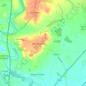
Nom : Carte topographique Bletchingdon, altitude, relief.
Altitude moyenne : 76 m
Altitude minimum : 57 m
Altitude maximum : 111 m
Autres cartes topographiques
Cliquez sur une carte pour visualiser sa topographie, son altitude et son relief.
Roman Meadow Banbury Country Park
United Kingdom > England > Oxfordshire > Cherwell District > Little Bourton
Altitude moyenne : 103 m
Nethercote
United Kingdom > England > Oxfordshire > Cherwell District > Banbury
Altitude moyenne : 111 m
Williamscot
United Kingdom > England > Oxfordshire > Cherwell District > Cropredy > Williamscot
Altitude moyenne : 118 m
Down End
United Kingdom > England > Oxfordshire > Cherwell District > Hook Norton
Altitude moyenne : 173 m
Stoke Lyne
United Kingdom > England > Oxfordshire > Cherwell District > Stoke Lyne
Altitude moyenne : 116 m
Shipton-on-Cherwell
United Kingdom > England > Oxfordshire > Cherwell District
Altitude moyenne : 78 m
Hampton Gay
United Kingdom > England > Oxfordshire > Cherwell District > Shipton-on-Cherwell
Altitude moyenne : 75 m
Little Chesterton
United Kingdom > England > Oxfordshire > Cherwell District > Wendlebury
Altitude moyenne : 72 m
Nethercote
United Kingdom > England > Oxfordshire > Cherwell District > Banbury
Altitude moyenne : 111 m