
Faire un don
Équipez-vous pour votre prochaine aventure :
En tant que Partenaire Amazon, ce site perçoit une commission sur les achats éligibles sans surcoût pour vous.
Carte topographique South Fulton
Cliquez sur la carte pour afficher l’altitude.
Faire un don
Équipez-vous pour votre prochaine aventure :
En tant que Partenaire Amazon, ce site perçoit une commission sur les achats éligibles sans surcoût pour vous.
À propos de cette carte
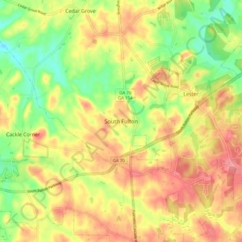
Nom : Carte topographique South Fulton, altitude, relief.
Lieu : South Fulton, Fulton County, Georgia, United States (33.55027 -84.71123 33.63027 -84.63123)
Altitude moyenne : 272 m
Altitude minimum : 220 m
Altitude maximum : 319 m
Faire un don
Équipez-vous pour votre prochaine aventure :
En tant que Partenaire Amazon, ce site perçoit une commission sur les achats éligibles sans surcoût pour vous.
Autres cartes topographiques
Cliquez sur une carte pour visualiser sa topographie, son altitude et son relief.
Atlanta
United States > Georgia > Fulton County
Atlanta features a varied topography characterized by its rolling hills and elevated terrain. The city sits at an average elevation of approximately 1,050 feet (320 meters) above sea level, with elevations ranging from about 725 feet (221 meters) to 1,175 feet (358 meters) in the surrounding areas. This…
Altitude moyenne : 284 m
Faire un don
Équipez-vous pour votre prochaine aventure :
En tant que Partenaire Amazon, ce site perçoit une commission sur les achats éligibles sans surcoût pour vous.
Johns Creek
United States > Georgia > Fulton County
Johns Creek is located in northeastern Fulton County and is centered at 34°1′44″N 84°11′55″W / 34.02889°N 84.19861°W / 34.02889; -84.19861 (34.0289259, -84.1985790). The elevation ranges from 880 feet (270 m) above sea level along the Chattahoochee River to 1,180 feet (360 m) in the Ocee…
Altitude moyenne : 314 m
Milton
United States > Georgia > Fulton County
According to the U.S. Census Bureau, the city of Milton has a total area of 39.2 square miles (101.4 km2), of which 38.5 square miles (99.8 km2) is land and 0.62 square miles (1.6 km2), or 1.59%, is water. The elevation ranges from 950 to 1,280 feet (290 to 390 m) above sea level.
Altitude moyenne : 330 m
Faire un don
Équipez-vous pour votre prochaine aventure :
En tant que Partenaire Amazon, ce site perçoit une commission sur les achats éligibles sans surcoût pour vous.
Faire un don
Équipez-vous pour votre prochaine aventure :
En tant que Partenaire Amazon, ce site perçoit une commission sur les achats éligibles sans surcoût pour vous.
Atlanta
United States > Georgia > Fulton County
Atlanta (/ætˈlæntə/ at-LAN-tə, or /ætˈlænə/ at-LAN-ə) is the capital and most populous city of the U.S. state of Georgia. It is the seat of Fulton County, although a portion of the city extends into neighboring DeKalb County. With a population of 498,715 living within the city limits, Atlanta is the…
Altitude moyenne : 284 m
Atlanta
United States > Georgia > Fulton County
Atlanta (/ætˈlæntə/ at-LAN-tə) is the capital and most populous city of the U.S. state of Georgia. It is the seat of Fulton County, the most populous county in Georgia, although a portion of the city extends into neighboring DeKalb county. With a population of 498,715 living within the city limits, it is…
Altitude moyenne : 284 m
Atlanta
United States > Georgia > Fulton County
Atlanta (/ætˈlæn(t)ə/ at-LAN-(t)ə) is the capital and most populous city in the U.S. state of Georgia. It is the seat of Fulton County, and a portion of the city extends into neighboring DeKalb County. While not included in city limits, unincorporated areas that carry an Atlanta address spill into…
Altitude moyenne : 284 m
Faire un don
Équipez-vous pour votre prochaine aventure :
En tant que Partenaire Amazon, ce site perçoit une commission sur les achats éligibles sans surcoût pour vous.
Faire un don
Équipez-vous pour votre prochaine aventure :
En tant que Partenaire Amazon, ce site perçoit une commission sur les achats éligibles sans surcoût pour vous.
Milton
United States > Georgia > Fulton County
According to the U.S. Census Bureau, the city of Milton has a total area of 39.2 square miles (101.4 km2), of which 38.5 square miles (99.8 km2) is land and 0.62 square miles (1.6 km2), or 1.59%, is water. The elevation ranges from 950 to 1,280 feet (290 to 390 m) above sea level.
Altitude moyenne : 330 m
Atlanta
United States > Georgia > Fulton County
Atlanta (/ætˈlæn(t)ə/ at-LAN-(t)ə) is the capital and most populous city in the U.S. state of Georgia. It is the seat of Fulton County, and a portion of the city extends into neighboring DeKalb County. With a population of 498,715 living within the city limits, Atlanta is the eighth most populous city in…
Altitude moyenne : 284 m
Faire un don
Équipez-vous pour votre prochaine aventure :
En tant que Partenaire Amazon, ce site perçoit une commission sur les achats éligibles sans surcoût pour vous.
Atlanta
United States > Georgia > Fulton County
Atlanta (/ætˈlæntə/ at-LAN-tə) is the capital and most populous city in the U.S. state of Georgia. It is the seat of Fulton County, and a portion of the city extends into neighboring DeKalb County. With a population of 510,823 living within the city limits, Atlanta is the eighth most populous city in the…
Altitude moyenne : 284 m
Atlanta
United States > Georgia > Fulton County
Atlanta (/ætˈlæntə/ at-LAN-tə) is the capital and most populous city in the U.S. state of Georgia. It is the seat of Fulton County, and a portion of the city extends into neighboring DeKalb County. With a population of 510,823 (2023 estimate) living within the city limits, Atlanta is the eighth most…
Altitude moyenne : 284 m
Johns Creek
United States > Georgia > Fulton County
Johns Creek is located in northeastern Fulton County. The elevation ranges from 880 feet (270 m) above sea level along the Chattahoochee River to 1,180 feet (360 m) in the Ocee area along the Alpharetta border. Johns Creek is bounded to the south by the Chattahoochee River and Gwinnett County, and on the…
Altitude moyenne : 314 m
Faire un don
Équipez-vous pour votre prochaine aventure :
En tant que Partenaire Amazon, ce site perçoit une commission sur les achats éligibles sans surcoût pour vous.
Faire un don
Équipez-vous pour votre prochaine aventure :
En tant que Partenaire Amazon, ce site perçoit une commission sur les achats éligibles sans surcoût pour vous.
Faire un don
Équipez-vous pour votre prochaine aventure :
En tant que Partenaire Amazon, ce site perçoit une commission sur les achats éligibles sans surcoût pour vous.
Milton
United States > Georgia > Fulton County
According to the U.S. Census Bureau, the city of Milton has a total area of 39.2 square miles (101.4 km2), of which 38.5 square miles (99.8 km2) is land and 0.62 square miles (1.6 km2), or 1.59%, is water. The elevation ranges from 950 to 1,280 feet (290 to 390 m) above sea level.
Altitude moyenne : 330 m
Faire un don
Équipez-vous pour votre prochaine aventure :
En tant que Partenaire Amazon, ce site perçoit une commission sur les achats éligibles sans surcoût pour vous.