
Carte topographique Knockadea
Cliquez sur la carte pour afficher l’altitude.
À propos de cette carte
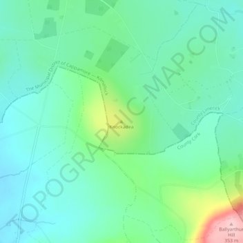
Nom : Carte topographique Knockadea, altitude, relief.
Altitude moyenne : 203 m
Altitude minimum : 155 m
Altitude maximum : 352 m
Autres cartes topographiques
Cliquez sur une carte pour visualiser sa topographie, son altitude et son relief.
Coolnahila (Palmer)
Ireland > County Limerick > The Municipal District of Cappamore — Kilmallock
Altitude moyenne : 39 m
Coolfree
Ireland > County Limerick > The Municipal District of Cappamore — Kilmallock
Altitude moyenne : 254 m
Kilmallock
Ireland > County Limerick > The Municipal District of Cappamore — Kilmallock
Altitude moyenne : 89 m
Kilmurry
Ireland > County Limerick > The Municipal District of Cappamore — Kilmallock
Altitude moyenne : 90 m
Kilfinnane
Ireland > County Limerick > The Municipal District of Cappamore — Kilmallock
At an elevation of over 150 metres (500 ft), Kilfinnane is the highest town in County Limerick. It is surrounded on three sides by the Ballyhoura Mountains, and on the fourth side is the "Golden Vale" region that runs through Counties Limerick, Cork, and Tipperary.
Altitude moyenne : 160 m
Darranstown
Ireland > County Limerick > The Municipal District of Cappamore — Kilmallock
Altitude moyenne : 108 m
Ballylanders
Ireland > County Limerick > The Municipal District of Cappamore — Kilmallock
Altitude moyenne : 157 m
Knockainy
Ireland > County Limerick > The Municipal District of Cappamore — Kilmallock
Altitude moyenne : 86 m
Drombane
Ireland > County Limerick > The Municipal District of Cappamore — Kilmallock
Altitude moyenne : 50 m
Aherlow
Ireland > County Limerick > The Municipal District of Cappamore — Kilmallock
Altitude moyenne : 141 m
Kilflynn Particles Parish Union
Ireland > County Limerick > The Municipal District of Cappamore — Kilmallock
Altitude moyenne : 211 m
Pallasbeg
Ireland > County Limerick > The Municipal District of Cappamore — Kilmallock
Altitude moyenne : 49 m
Cullane South
Ireland > County Limerick > The Municipal District of Cappamore — Kilmallock
Altitude moyenne : 152 m
Clare Glens
Ireland > County Limerick > The Municipal District of Cappamore — Kilmallock
Altitude moyenne : 124 m
Glenstal
Ireland > County Limerick > The Municipal District of Cappamore — Kilmallock
Altitude moyenne : 147 m
Coolattin
Ireland > County Limerick > The Municipal District of Cappamore — Kilmallock
Altitude moyenne : 222 m
Caherconlish
Ireland > County Limerick > The Municipal District of Cappamore — Kilmallock
Altitude moyenne : 79 m
Tobernea
Ireland > County Limerick > The Municipal District of Cappamore — Kilmallock
Altitude moyenne : 93 m
Anglesborough
Ireland > County Limerick > The Municipal District of Cappamore — Kilmallock
Altitude moyenne : 229 m
Barna
Ireland > County Limerick > The Municipal District of Cappamore — Kilmallock
Altitude moyenne : 249 m
Dromin
Ireland > County Limerick > The Municipal District of Cappamore — Kilmallock
Altitude moyenne : 73 m
Garranbane
Ireland > County Limerick > The Municipal District of Cappamore — Kilmallock
Altitude moyenne : 143 m
Ballyvalode
Ireland > County Limerick > The Municipal District of Cappamore — Kilmallock
Altitude moyenne : 66 m
Ballysallagh
Ireland > County Limerick > The Municipal District of Cappamore — Kilmallock
Altitude moyenne : 80 m
Knocknascrow
Ireland > County Limerick > The Municipal District of Cappamore — Kilmallock
Altitude moyenne : 306 m
Tullabeg
Ireland > County Limerick > The Municipal District of Cappamore — Kilmallock
Altitude moyenne : 67 m
Oola
Ireland > County Limerick > The Municipal District of Cappamore — Kilmallock
Altitude moyenne : 77 m
Nicker
Ireland > County Limerick > The Municipal District of Cappamore — Kilmallock
Altitude moyenne : 83 m
Kilmallock
Ireland > County Limerick > The Municipal District of Cappamore — Kilmallock
Altitude moyenne : 90 m
Muingacree
Ireland > County Limerick > The Municipal District of Cappamore — Kilmallock
Altitude moyenne : 268 m
Ballinscaula
Ireland > County Limerick > The Municipal District of Cappamore — Kilmallock
Altitude moyenne : 106 m
Ballyshoneen
Ireland > County Limerick > The Municipal District of Cappamore — Kilmallock
Altitude moyenne : 79 m
Toomaline Upper
Ireland > County Limerick > The Municipal District of Cappamore — Kilmallock
Altitude moyenne : 122 m
Doon South
Ireland > County Limerick > The Municipal District of Cappamore — Kilmallock
Altitude moyenne : 101 m
Anglesborough
Ireland > County Limerick > The Municipal District of Cappamore — Kilmallock
Altitude moyenne : 229 m
Doon
Ireland > County Limerick > The Municipal District of Cappamore — Kilmallock
Altitude moyenne : 112 m
Mounteagle
Ireland > County Limerick > The Municipal District of Cappamore — Kilmallock
Altitude moyenne : 63 m
Brickfield
Ireland > County Limerick > The Municipal District of Cappamore — Kilmallock
Altitude moyenne : 123 m
Dead
Ireland > County Limerick > The Municipal District of Cappamore — Kilmallock
Altitude moyenne : 62 m