
Faire un don
Équipez-vous pour votre prochaine aventure :
En tant que Partenaire Amazon, ce site perçoit une commission sur les achats éligibles sans surcoût pour vous.
Carte topographique Coolnahila (Palmer)
Cliquez sur la carte pour afficher l’altitude.
Faire un don
Équipez-vous pour votre prochaine aventure :
En tant que Partenaire Amazon, ce site perçoit une commission sur les achats éligibles sans surcoût pour vous.
À propos de cette carte
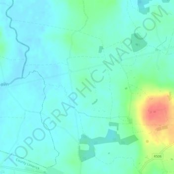
Nom : Carte topographique Coolnahila (Palmer), altitude, relief.
Altitude moyenne : 39 m
Altitude minimum : 27 m
Altitude maximum : 84 m
Faire un don
Équipez-vous pour votre prochaine aventure :
En tant que Partenaire Amazon, ce site perçoit une commission sur les achats éligibles sans surcoût pour vous.
Autres cartes topographiques
Cliquez sur une carte pour visualiser sa topographie, son altitude et son relief.
Kilcruaig
Ireland > County Limerick > The Municipal District of Cappamore — Kilmallock
Altitude moyenne : 200 m
Knockadea
Ireland > County Limerick > The Municipal District of Cappamore — Kilmallock
Altitude moyenne : 203 m
Pallasgreen
Ireland > County Limerick > The Municipal District of Cappamore — Kilmallock
Altitude moyenne : 72 m
Galtymore
Ireland > County Limerick > The Municipal District of Cappamore — Kilmallock
Galtymore or Galteemore (Irish: Cnoc Mór na nGaibhlte, meaning 'big hill of the Galtees') is a mountain in the province of Munster, Ireland. At 917.9 metres (3,011 ft 6 in), it is one of Ireland's highest mountains, being the 12th-highest on the Arderin list, and 14th-highest on the Vandeleur-Lynam list.…
Altitude moyenne : 594 m
Faire un don
Équipez-vous pour votre prochaine aventure :
En tant que Partenaire Amazon, ce site perçoit une commission sur les achats éligibles sans surcoût pour vous.
Aherlow
Ireland > County Limerick > The Municipal District of Cappamore — Kilmallock
Altitude moyenne : 141 m
Clare Glens
Ireland > County Limerick > The Municipal District of Cappamore — Kilmallock
Altitude moyenne : 124 m
Ardpatrick
Ireland > County Limerick > The Municipal District of Cappamore — Kilmallock
Altitude moyenne : 169 m
Bruff
Ireland > County Limerick > The Municipal District of Cappamore — Kilmallock
Altitude moyenne : 68 m
Faire un don
Équipez-vous pour votre prochaine aventure :
En tant que Partenaire Amazon, ce site perçoit une commission sur les achats éligibles sans surcoût pour vous.
Bruree
Ireland > County Limerick > The Municipal District of Cappamore — Kilmallock
Altitude moyenne : 62 m