
Faire un don
Équipez-vous pour votre prochaine aventure :
En tant que Partenaire Amazon, ce site perçoit une commission sur les achats éligibles sans surcoût pour vous.
Carte topographique Galtymore
Cliquez sur la carte pour afficher l’altitude.
Faire un don
Équipez-vous pour votre prochaine aventure :
En tant que Partenaire Amazon, ce site perçoit une commission sur les achats éligibles sans surcoût pour vous.
Galtymore
Galtymore or Galteemore (Irish: Cnoc Mór na nGaibhlte, meaning 'big hill of the Galtees') is a mountain in the province of Munster, Ireland. At 917.9 metres (3,011 ft 6 in), it is one of Ireland's highest mountains, being the 12th-highest on the Arderin list, and 14th-highest on the Vandeleur-Lynam list. Galtymore has the 4th-highest topographic prominence of any peak in Ireland, which classifies Galtymore as a P600, or "major mountain". It is one of the 13 Irish Munros.
Faire un don
Équipez-vous pour votre prochaine aventure :
En tant que Partenaire Amazon, ce site perçoit une commission sur les achats éligibles sans surcoût pour vous.
À propos de cette carte
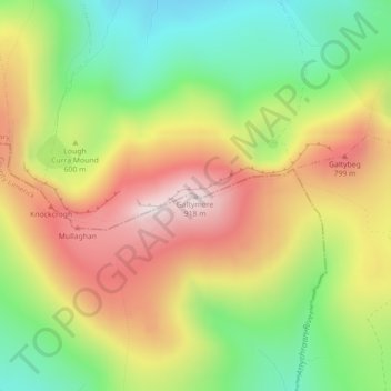
Nom : Carte topographique Galtymore, altitude, relief.
Altitude moyenne : 594 m
Altitude minimum : 308 m
Altitude maximum : 904 m
Faire un don
Équipez-vous pour votre prochaine aventure :
En tant que Partenaire Amazon, ce site perçoit une commission sur les achats éligibles sans surcoût pour vous.
Autres cartes topographiques
Cliquez sur une carte pour visualiser sa topographie, son altitude et son relief.
Kilmallock
Ireland > County Limerick > The Municipal District of Cappamore — Kilmallock
Altitude moyenne : 89 m
Kilmurry
Ireland > County Limerick > The Municipal District of Cappamore — Kilmallock
Altitude moyenne : 90 m
Kilfinnane
Ireland > County Limerick > The Municipal District of Cappamore — Kilmallock
At an elevation of over 150 metres (500 ft), Kilfinnane is the highest town in County Limerick. It is surrounded on three sides by the Ballyhoura Mountains, and on the fourth side is the "Golden Vale" region that runs through Counties Limerick, Cork, and Tipperary.
Altitude moyenne : 160 m
Darranstown
Ireland > County Limerick > The Municipal District of Cappamore — Kilmallock
Altitude moyenne : 108 m
Faire un don
Équipez-vous pour votre prochaine aventure :
En tant que Partenaire Amazon, ce site perçoit une commission sur les achats éligibles sans surcoût pour vous.
Ballylanders
Ireland > County Limerick > The Municipal District of Cappamore — Kilmallock
Altitude moyenne : 157 m
Knockainy
Ireland > County Limerick > The Municipal District of Cappamore — Kilmallock
Altitude moyenne : 86 m
Drombane
Ireland > County Limerick > The Municipal District of Cappamore — Kilmallock
Altitude moyenne : 50 m
Aherlow
Ireland > County Limerick > The Municipal District of Cappamore — Kilmallock
Altitude moyenne : 141 m
Faire un don
Équipez-vous pour votre prochaine aventure :
En tant que Partenaire Amazon, ce site perçoit une commission sur les achats éligibles sans surcoût pour vous.
Clare Glens
Ireland > County Limerick > The Municipal District of Cappamore — Kilmallock
Altitude moyenne : 124 m
Glenstal
Ireland > County Limerick > The Municipal District of Cappamore — Kilmallock
Altitude moyenne : 147 m
Coolattin
Ireland > County Limerick > The Municipal District of Cappamore — Kilmallock
Altitude moyenne : 222 m
Caherconlish
Ireland > County Limerick > The Municipal District of Cappamore — Kilmallock
Altitude moyenne : 79 m
Faire un don
Équipez-vous pour votre prochaine aventure :
En tant que Partenaire Amazon, ce site perçoit une commission sur les achats éligibles sans surcoût pour vous.
Coolfree
Ireland > County Limerick > The Municipal District of Cappamore — Kilmallock
Altitude moyenne : 254 m
Tobernea
Ireland > County Limerick > The Municipal District of Cappamore — Kilmallock
Altitude moyenne : 93 m
Anglesborough
Ireland > County Limerick > The Municipal District of Cappamore — Kilmallock
Altitude moyenne : 229 m
Barna
Ireland > County Limerick > The Municipal District of Cappamore — Kilmallock
Altitude moyenne : 249 m
Faire un don
Équipez-vous pour votre prochaine aventure :
En tant que Partenaire Amazon, ce site perçoit une commission sur les achats éligibles sans surcoût pour vous.
Dromin
Ireland > County Limerick > The Municipal District of Cappamore — Kilmallock
Altitude moyenne : 73 m
Garranbane
Ireland > County Limerick > The Municipal District of Cappamore — Kilmallock
Altitude moyenne : 143 m
Ballyvalode
Ireland > County Limerick > The Municipal District of Cappamore — Kilmallock
Altitude moyenne : 66 m
Ballysallagh
Ireland > County Limerick > The Municipal District of Cappamore — Kilmallock
Altitude moyenne : 80 m
Faire un don
Équipez-vous pour votre prochaine aventure :
En tant que Partenaire Amazon, ce site perçoit une commission sur les achats éligibles sans surcoût pour vous.
Knocknascrow
Ireland > County Limerick > The Municipal District of Cappamore — Kilmallock
Altitude moyenne : 306 m
Tullabeg
Ireland > County Limerick > The Municipal District of Cappamore — Kilmallock
Altitude moyenne : 67 m
Oola
Ireland > County Limerick > The Municipal District of Cappamore — Kilmallock
Altitude moyenne : 77 m
Nicker
Ireland > County Limerick > The Municipal District of Cappamore — Kilmallock
Altitude moyenne : 83 m
Faire un don
Équipez-vous pour votre prochaine aventure :
En tant que Partenaire Amazon, ce site perçoit une commission sur les achats éligibles sans surcoût pour vous.
Kilmallock
Ireland > County Limerick > The Municipal District of Cappamore — Kilmallock
Altitude moyenne : 90 m
Ballyshoneen
Ireland > County Limerick > The Municipal District of Cappamore — Kilmallock
Altitude moyenne : 79 m
Muingacree
Ireland > County Limerick > The Municipal District of Cappamore — Kilmallock
Altitude moyenne : 268 m
Kilflynn Particles Parish Union
Ireland > County Limerick > The Municipal District of Cappamore — Kilmallock
Altitude moyenne : 211 m
Faire un don
Équipez-vous pour votre prochaine aventure :
En tant que Partenaire Amazon, ce site perçoit une commission sur les achats éligibles sans surcoût pour vous.
Toomaline Upper
Ireland > County Limerick > The Municipal District of Cappamore — Kilmallock
Altitude moyenne : 122 m
Pallasbeg
Ireland > County Limerick > The Municipal District of Cappamore — Kilmallock
Altitude moyenne : 49 m
Ballinscaula
Ireland > County Limerick > The Municipal District of Cappamore — Kilmallock
Altitude moyenne : 106 m
Cullane South
Ireland > County Limerick > The Municipal District of Cappamore — Kilmallock
Altitude moyenne : 152 m
Faire un don
Équipez-vous pour votre prochaine aventure :
En tant que Partenaire Amazon, ce site perçoit une commission sur les achats éligibles sans surcoût pour vous.
Coolnahila (Palmer)
Ireland > County Limerick > The Municipal District of Cappamore — Kilmallock
Altitude moyenne : 39 m
Doon
Ireland > County Limerick > The Municipal District of Cappamore — Kilmallock
Altitude moyenne : 112 m
Anglesborough
Ireland > County Limerick > The Municipal District of Cappamore — Kilmallock
Altitude moyenne : 229 m
Brickfield
Ireland > County Limerick > The Municipal District of Cappamore — Kilmallock
Altitude moyenne : 123 m
Faire un don
Équipez-vous pour votre prochaine aventure :
En tant que Partenaire Amazon, ce site perçoit une commission sur les achats éligibles sans surcoût pour vous.
Mounteagle
Ireland > County Limerick > The Municipal District of Cappamore — Kilmallock
Altitude moyenne : 63 m
Dead
Ireland > County Limerick > The Municipal District of Cappamore — Kilmallock
Altitude moyenne : 62 m