
Faire un don
Équipez-vous pour votre prochaine aventure :
En tant que Partenaire Amazon, ce site perçoit une commission sur les achats éligibles sans surcoût pour vous.
Carte topographique Frontera
Cliquez sur la carte pour afficher l’altitude.
Faire un don
Équipez-vous pour votre prochaine aventure :
En tant que Partenaire Amazon, ce site perçoit une commission sur les achats éligibles sans surcoût pour vous.
À propos de cette carte
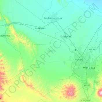
Nom : Carte topographique Frontera, altitude, relief.
Lieu : Frontera, Coahuila, Mexico (26.80669 -101.71699 27.10073 -101.34880)
Altitude moyenne : 666 m
Altitude minimum : 437 m
Altitude maximum : 1 642 m
Faire un don
Équipez-vous pour votre prochaine aventure :
En tant que Partenaire Amazon, ce site perçoit une commission sur les achats éligibles sans surcoût pour vous.
Autres cartes topographiques
Cliquez sur une carte pour visualiser sa topographie, son altitude et son relief.
Ejido Santo Tomas
Mexico > Coahuila > Matamoros > Colonia Enrique Martinez y Martinez
Altitude moyenne : 1 116 m
Faire un don
Équipez-vous pour votre prochaine aventure :
En tant que Partenaire Amazon, ce site perçoit une commission sur les achats éligibles sans surcoût pour vous.
Saltillo
El Cerro del Pueblo (The Town Hill) and its 4-metre (13 ft) cross overlook the city. The city's elevation makes it colder and windier than the neighboring city of Monterrey. Saltillo lies in the Chihuahuan Desert near the city of Arteaga. The city is flanked by the Zapalinamé mountains, which are part of the…
Altitude moyenne : 1 857 m
Faire un don
Équipez-vous pour votre prochaine aventure :
En tant que Partenaire Amazon, ce site perçoit une commission sur les achats éligibles sans surcoût pour vous.
Ramos Arizpe
Mexico > Coahuila > Ramos Arizpe
Ramos Arizpe has a desert climate (Köppen climate classification BWh Owing to its altitude of 1,400 to 1,500 m (4,600 to 4,900 ft) above sea level, temperatures are milder than other desert cities at lower elevations. Winters are mild with warm temperatures during the day and cold nights. The January average…
Altitude moyenne : 1 426 m
Faire un don
Équipez-vous pour votre prochaine aventure :
En tant que Partenaire Amazon, ce site perçoit une commission sur les achats éligibles sans surcoût pour vous.
Saltillo
El Cerro del Pueblo (The People's Hill) and its 4-metre (13 ft) cross overlook the city. The city's elevation makes it colder and windier than the neighboring city of Monterrey. Saltillo lies in the Chihuahuan Desert near the city of Arteaga. The city is flanked by the Zapalinamé mountains, which are part of…
Altitude moyenne : 1 857 m
Faire un don
Équipez-vous pour votre prochaine aventure :
En tant que Partenaire Amazon, ce site perçoit une commission sur les achats éligibles sans surcoût pour vous.
Piedras Negras
Mexico > Coahuila > Municipio de Piedras Negras > Piedras Negras
Altitude moyenne : 256 m
Saltillo
El Cerro del Pueblo (The Town Hill) and its 4-metre (13 ft) cross overlook the city. The city's elevation makes it colder and windier than the neighboring city of Monterrey. Saltillo lies in the Chihuahuan Desert near the city of Arteaga. The city is flanked by the Zapalinamé mountains, which are part of the…
Altitude moyenne : 1 857 m