
Carte topographique Canfranc
Carte interactive
Cliquez sur la carte pour afficher l’altitude.
À propos de cette carte
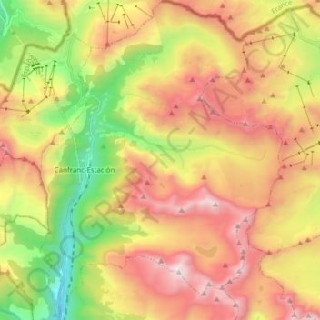
Nom : Carte topographique Canfranc, altitude, relief.
Lieu : Canfranc, Jacetania, Huesca, Aragon, 22880, Spain (42.69725 -0.53755 42.80944 -0.42112)
Altitude moyenne : 1 862 m
Altitude minimum : 994 m
Altitude maximum : 2 872 m
The village, which lies in the valley of the Aragón River, covers an area of 71.6 km2 (27.6 sq mi) and is situated at an altitude of 1,040 m (3,410 ft). The remains to be seen include a Romanesque pilgrim's bridge and two churches of interest: Nuestra Señora de la Asunción (12th to 16th centuries) with four baroque retablos, and La Trinidad (16th century). The town was obliterated by fire in 1617 and again in 1944, after which the villagers for the most part moved to nearby Canfranc Station. The current population is 77.
Autres cartes topographiques
Cliquez sur une carte pour visualiser sa topographie, son altitude et son relief.