
Carte topographique Staythorpe CP
Carte interactive
Cliquez sur la carte pour afficher l’altitude.
À propos de cette carte
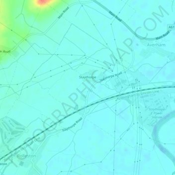
Nom : Carte topographique Staythorpe CP, altitude, relief.
Altitude moyenne : 16 m
Altitude minimum : 9 m
Altitude maximum : 58 m
The land is very low-lying and level, varying little in elevation between 12–14 metres (39–46 ft) throughout.
Autres cartes topographiques
Cliquez sur une carte pour visualiser sa topographie, son altitude et son relief.
Newark on Trent
United Kingdom > England > Nottinghamshire > Newark and Sherwood
Newark on Trent, Newark and Sherwood, Nottinghamshire, England, NG24 1EJ, United Kingdom
Altitude moyenne : 18 m
Sherwood Forest NNR
United Kingdom > England > Nottinghamshire > Newark and Sherwood > Ollerton
Sherwood Forest NNR, Ollerton, Newark and Sherwood, Nottinghamshire, England, NG21 9HN, United Kingdom
Altitude moyenne : 71 m
Southwell CP
United Kingdom > England > Nottinghamshire > Newark and Sherwood
Southwell CP, Newark and Sherwood, Nottinghamshire, England, United Kingdom
Altitude moyenne : 47 m
Goverton
United Kingdom > England > Nottinghamshire > Newark and Sherwood > Bleasby
Goverton, Bleasby, Newark and Sherwood, Nottinghamshire, England, NG14 7FN, United Kingdom
Altitude moyenne : 33 m