
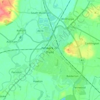
Carte topographique Newark on Trent
Carte interactive
Cliquez sur la carte pour afficher l’altitude.
À propos de cette carte
Nom : Carte topographique Newark on Trent, altitude, relief.
Altitude moyenne : 18 m
Altitude minimum : 1 m
Altitude maximum : 72 m
Autres cartes topographiques
Cliquez sur une carte pour visualiser sa topographie, son altitude et son relief.
Staythorpe CP
United Kingdom > England > Nottinghamshire > Newark and Sherwood
Staythorpe CP, Newark and Sherwood, Nottinghamshire, England, United Kingdom
Altitude moyenne : 16 m
Sherwood Forest NNR
United Kingdom > England > Nottinghamshire > Newark and Sherwood > Ollerton
Sherwood Forest NNR, Ollerton, Newark and Sherwood, Nottinghamshire, England, NG21 9HN, United Kingdom
Altitude moyenne : 71 m
Southwell CP
United Kingdom > England > Nottinghamshire > Newark and Sherwood
Southwell CP, Newark and Sherwood, Nottinghamshire, England, United Kingdom
Altitude moyenne : 47 m
Goverton
United Kingdom > England > Nottinghamshire > Newark and Sherwood > Bleasby
Goverton, Bleasby, Newark and Sherwood, Nottinghamshire, England, NG14 7FN, United Kingdom
Altitude moyenne : 33 m