
Carte topographique Densole
Carte interactive
Cliquez sur la carte pour afficher l’altitude.
À propos de cette carte
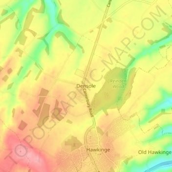
Nom : Carte topographique Densole, altitude, relief.
Altitude moyenne : 146 m
Altitude minimum : 89 m
Altitude maximum : 189 m
Autres cartes topographiques
Cliquez sur une carte pour visualiser sa topographie, son altitude et son relief.
Hythe
United Kingdom > England > Kent > Folkestone and Hythe District
Hythe, Folkestone and Hythe District, Kent, England, United Kingdom
Altitude moyenne : 32 m
Folkestone
United Kingdom > England > Kent > Folkestone and Hythe District
Folkestone, Folkestone and Hythe District, Kent, England, United Kingdom
Altitude moyenne : 62 m
Park Gate
United Kingdom > England > Kent > Folkestone and Hythe District > Elham
Park Gate, Elham, Folkestone and Hythe District, Kent, England, CT4 6BH, United Kingdom
Altitude moyenne : 130 m
Lympne
United Kingdom > England > Kent > Folkestone and Hythe District
Lympne, Folkestone and Hythe District, Kent, England, United Kingdom
Altitude moyenne : 56 m
Littlestone on Sea
United Kingdom > England > Kent > Folkestone and Hythe District > New Romney
Littlestone on Sea, New Romney, Folkestone and Hythe District, Kent, England, TN28 8QU, United Kingdom
Altitude moyenne : 1 m