
Faire un don
Équipez-vous pour votre prochaine aventure :
En tant que Partenaire Amazon, ce site perçoit une commission sur les achats éligibles sans surcoût pour vous.
Carte topographique Jumping Pound
Cliquez sur la carte pour afficher l’altitude.
Faire un don
Équipez-vous pour votre prochaine aventure :
En tant que Partenaire Amazon, ce site perçoit une commission sur les achats éligibles sans surcoût pour vous.
À propos de cette carte
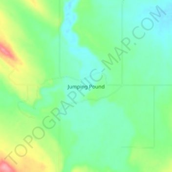
Nom : Carte topographique Jumping Pound, altitude, relief.
Lieu : Jumping Pound, Rocky View County, Alberta, Canada (51.05667 -114.56000 51.07667 -114.54000)
Altitude moyenne : 1 249 m
Altitude minimum : 1 226 m
Altitude maximum : 1 280 m
Faire un don
Équipez-vous pour votre prochaine aventure :
En tant que Partenaire Amazon, ce site perçoit une commission sur les achats éligibles sans surcoût pour vous.
Autres cartes topographiques
Cliquez sur une carte pour visualiser sa topographie, son altitude et son relief.
Faire un don
Équipez-vous pour votre prochaine aventure :
En tant que Partenaire Amazon, ce site perçoit une commission sur les achats éligibles sans surcoût pour vous.
Langdon
Canada > Alberta > Rocky View County
Langdon is located 12 km (7.5 mi) east of the City of Calgary at the intersection of Highway 560 (Glenmore Trail) and Highway 797, approximately 6 km (3.7 mi) south of the Trans Canada Highway and 7 km (4.3 mi) north of Highway 22X. It has an elevation of 1,005 m (3,297 ft).
Altitude moyenne : 1 007 m