
Faire un don
Équipez-vous pour votre prochaine aventure :
En tant que Partenaire Amazon, ce site perçoit une commission sur les achats éligibles sans surcoût pour vous.
Carte topographique Baxter State Park
Cliquez sur la carte pour afficher l’altitude.
Faire un don
Équipez-vous pour votre prochaine aventure :
En tant que Partenaire Amazon, ce site perçoit une commission sur les achats éligibles sans surcoût pour vous.
Baxter State Park
After assuming the Maine Senate presidency during the state's 80th legislative session, Percival Baxter appointed his brother Rupert, a Senator from Sagadahoc County, to the Committee on State Lands and Forest Preservation, which would be considering legislation that would create a state park at Katahdin. Baxter introduced on January 25, 1921 “AN ACT to Establish the Mt. Katahdin State Park” (80th Legislature, Senate No. 19). The unexpected death of Governor Frederick H. Parkhurst on January 31, 1921 triggered Senate President Baxter’s elevation to the governorship. This unforeseen development dramatically changed the political fortunes of Baxter's park proposal. William F. Dawson's illustrated lecture, scheduled by Baxter for February 2, 1921, was cancelled, and in its stead legislators were filing past Parkhurst’s coffin laid out in the Capitol’s rotunda. Baxter, the newly inaugurated governor, was no longer able to direct legislative deliberations on his bill.
Faire un don
Équipez-vous pour votre prochaine aventure :
En tant que Partenaire Amazon, ce site perçoit une commission sur les achats éligibles sans surcoût pour vous.
À propos de cette carte
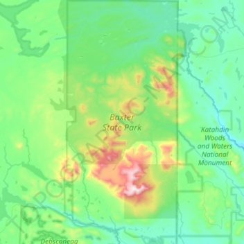
Nom : Carte topographique Baxter State Park, altitude, relief.
Lieu : Baxter State Park, Piscataquis County, Maine, United States (45.81423 -69.08618 46.21645 -68.76367)
Altitude moyenne : 377 m
Altitude minimum : 114 m
Altitude maximum : 1 580 m
Faire un don
Équipez-vous pour votre prochaine aventure :
En tant que Partenaire Amazon, ce site perçoit une commission sur les achats éligibles sans surcoût pour vous.
Autres cartes topographiques
Cliquez sur une carte pour visualiser sa topographie, son altitude et son relief.
Mount Katahdin
United States > Maine > Piscataquis County > Mount Katahdin Township
It is commonly thought that Katahdin is the first place in the United States mainland to receive sunlight in the morning, but this is incorrect. Other mountains lower in elevation but farther to the east or southeast see the first sunrise of the day, depending on the season. Regardless, the summit of Katahdin…
Altitude moyenne : 1 216 m
Fort Mountain
United States > Maine > Piscataquis County > T4 R10 WELS
On June 20, 1944, a C-54-A cargo plane on the Newfoundland to Washington, D.C. leg of trans-Atlantic TWA Flight 277 from England was pushed 70 miles (110 km) north of its planned course by stormy weather, which prevented obtaining visual or radio location fixes. The crew was unaware the aircraft had entered…
Altitude moyenne : 944 m
Mount Katahdin
United States > Maine > Piscataquis County > Mount Katahdin Township
It is commonly thought that Katahdin is the first place in the United States mainland to receive sunlight in the morning, but this is incorrect. Other mountains lower in elevation but farther to the east or southeast see the first sunrise of the day, depending on the season. Regardless, the summit of Katahdin…
Altitude moyenne : 1 216 m
Faire un don
Équipez-vous pour votre prochaine aventure :
En tant que Partenaire Amazon, ce site perçoit une commission sur les achats éligibles sans surcoût pour vous.
Fort Mountain
United States > Maine > Piscataquis County > T4 R10 WELS
On June 20, 1944, a C-54-A cargo plane on the Newfoundland to Washington, D.C. leg of trans-Atlantic TWA Flight 277 from England was pushed 70 miles (110 km) north of its planned course by stormy weather, which prevented obtaining visual or radio location fixes. The crew was unaware the aircraft had entered…
Altitude moyenne : 944 m